Earthquake north of Halmahera, Indonesia
Fri, 13 Feb 2026 15:09:21 GMT
Time6 days ago
Location
4.6689, 128.5546
Depth
10.0 KM
Event Summary
A 5.2 magnitude earthquake struck on north of Halmahera, Indonesia, at Fri, 13 Feb 2026 15:09:21 GMT. Depth: 10km. Reviewed by VYT seismologists, this moderate quake occurred at a magnitude type of earthquake.
Magnitude
5.2
earthquake
Source
VYT
Intensity
-
Agency Reports
5 Sources| Source | Magnitude | Depth | Time |
|---|---|---|---|
| VYTPrimary | 5.2 | 10 km | 6 days ago |
| BMKG | 5.1 | 40 km | 6 days ago |
| NEIC | 4.9 | 66 km | 6 days ago |
| USGS | 4.9 | 66 km | 6 days ago |
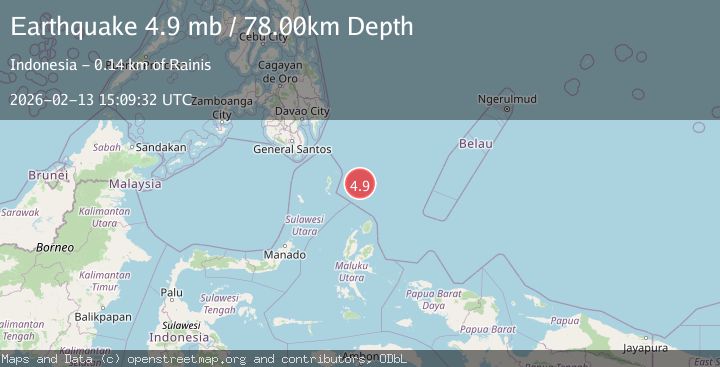
| EMSC | 4.9 | 78 km | 6 days ago |
Earthquake Details
AutomaticEvent IDvyt_161vzos8qwaom
Tsunami PotentialNo
Magnitude Typeearthquake
Nearest Places
- Snellius Ridge96.5 km
- Talaud Trough146.5 km
- Desa Kakorotan154.7 km
- Pulau Kakorotan154.7 km
- Pulau Intata154.8 km
Comments
Join the discussion about this event.
Latest Earthquakes
2.1Mag
SAN FRANCISCO BAY AREA, CALIF.
Time6 hours ago
Depth6.40 km
SourceNC (Automatic)
2.4Mag
Fox Islands, Aleutian Islands, Alaska
Time6 hours ago
Depth44.43 km
SourceVYT (Automatic)
2.4Mag
British Columbia, Canada
Time6 hours ago
Depth3.91 km
SourceVYT (Automatic)
2.0Mag
SWITZERLAND
Time6 hours ago
Depth0.10 km
SourceETHZ (Automatic)
2.0Mag
Southern Alaska
Time6 hours ago
Depth10.50 km
SourceVYT (Automatic)
Nearby Earthquakes
3.8Mag
North of Halmahera, Indonesia
Time6 days ago
Depth10.00 km
SourceBMKG
4.0Mag
North of Halmahera, Indonesia
Time5 days ago
Depth13.92 km
SourceBMKG
5.1Mag
north of Halmahera, Indonesia
Time6 days ago
Depth10.00 km
SourceVYT (Automatic)
4.4Mag
North of Halmahera, Indonesia
Time3 days ago
Depth10.00 km
SourceBMKG
4.0Mag
NORTH OF HALMAHERA, INDONESIA
Time9 months ago
Depth50.00 km
SourceBMKG (Automatic)