Earthquake north of Halmahera, Indonesia
Fri, 13 Feb 2026 15:55:09 GMT
Time5 days ago
Location
4.5231, 128.3132
Depth
10.0 KM
Event Summary
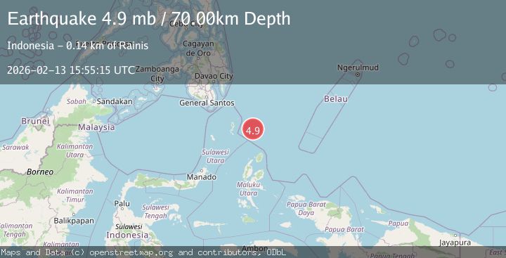
A 5.1 magnitude earthquake struck on north of Halmahera, Indonesia, at Fri, 13 Feb 2026 15:55:09 GMT. Depth: 10km. Reviewed by VYT seismologists, this moderate quake occurred at a magnitude type of earthquake.
Magnitude
5.1
earthquake
Source
VYT
Intensity
-
Agency Reports
6 Sources| Source | Magnitude | Depth | Time |
|---|---|---|---|
| VYTPrimary | 5.1 | 10 km | 5 days ago |
| BMKG | 4.9 | 10 km | 5 days ago |
| GFZ | 4.8 | 10 km | 5 days ago |
| EMSC | 4.9 | 70 km | 5 days ago |
| NEIC | 4.9 | 66 km | 5 days ago |
| USGS | 4.9 | 66 km | 5 days ago |
Earthquake Details
AutomaticEvent IDvyt_g8e4iwital4o
Tsunami PotentialNo
Magnitude Typeearthquake
Nearest Places
- Snellius Ridge67.7 km
- Talaud Trough115.2 km
- Pulau Kakorotan128.4 km
- Desa Kakorotan128.4 km
- Pulau Intata128.7 km
Comments
Join the discussion about this event.
Latest Earthquakes
1.2Mag
Central Alaska
Time12 hours ago
Depth0.85 km
SourceVYT (Automatic)
2.6Mag
West Papua Region, Indonesia
Time12 hours ago
Depth10.00 km
SourceBMKG
2.3Mag
WESTERN TURKEY
Time12 hours ago
Depth10.10 km
SourceKOERI (Automatic)
2.6Mag
Antofagasta, Chile
Time12 hours ago
Depth0.00 km
SourceVYT (Automatic)
2.8Mag
Fox Islands, Aleutian Islands, Alaska
Time12 hours ago
Depth80.44 km
SourceVYT (Automatic)
Nearby Earthquakes
3.1Mag
north of Halmahera, Indonesia
Time3 days ago
Depth10.00 km
SourceVYT (Automatic)
3.8Mag
North of Halmahera, Indonesia
Time5 days ago
Depth10.00 km
SourceBMKG
4.4Mag
North of Halmahera, Indonesia
Time3 days ago
Depth10.00 km
SourceBMKG
5.0Mag
North of Halmahera, Indonesia
Time5 days ago
Depth10.00 km
SourceBMKG
4.6Mag
north of Halmahera, Indonesia
Time1 day ago
Depth10.00 km
SourceVYT (Automatic)