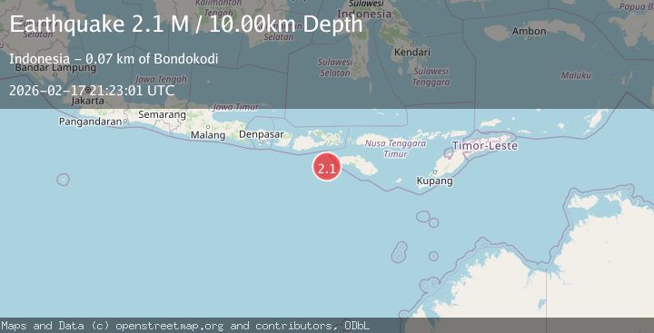
Earthquake Sumbawa Region, Indonesia
Tue, 17 Feb 2026 21:23:01 GMT
Time14 hours ago
Location
-9.8800, 118.4204
Depth
10.0 KM
Event Summary
A 2.1 magnitude earthquake struck on Sumbawa Region, Indonesia, at Tue, 17 Feb 2026 21:23:01 GMT. Depth: 10km. Reviewed by BMKG seismologists, this minor quake occurred at a magnitude type of M.
Magnitude
2.1
M
Source
BMKG
Intensity
-
Agency Reports
1 Sources| Source | Magnitude | Depth | Time |
|---|---|---|---|
| BMKGPrimary | 2.1 | 10 km | 14 hours ago |
Earthquake Details
ManualEvent IDbmg2026djmz
Tsunami PotentialNo
Magnitude TypeM
Nearest Places
- Tanjung Karosso58.3 km
- Tanjung Karoso66.4 km
- Bodokaha66.9 km
- Bukubani67.0 km
- Waikeroko67.0 km
Comments
Join the discussion about this event.
Latest Earthquakes
3.0Mag
Tarapaca, Chile
Time14 hours ago
Depth100.83 km
SourceVYT (Automatic)
3.3Mag
West Papua Region, Indonesia
Time14 hours ago
Depth10.00 km
SourceBMKG
2.4Mag
Java, Indonesia
Time14 hours ago
Depth14.70 km
SourceBMKG
2.2Mag
Flores Sea
Time14 hours ago
Depth28.79 km
SourceBMKG
1.3Mag
Kenai Peninsula, Alaska
Time14 hours ago
Depth21.00 km
SourceVYT (Automatic)
Nearby Earthquakes
2.4Mag
South of Sumbawa, Indonesia
Time6 days ago
Depth33.23 km
SourceBMKG
3.1Mag
Sumbawa region, Indonesia
Time6 days ago
Depth10.00 km
SourceVYT (Automatic)
2.7Mag
Sumbawa Region, Indonesia
Time1 week ago
Depth24.10 km
SourceBMKG (Automatic)
3.7Mag
SOUTH OF SUMBAWA, INDONESIA
Time1 month ago
Depth10.00 km
SourceBMKG (Automatic)
2.8Mag
Sumbawa Region, Indonesia
Time2 weeks ago
Depth13.16 km
SourceBMKG (Automatic)