Earthquake SOUTH OF SUMBAWA, INDONESIA
Tue, 13 Jan 2026 04:59:57 GMT
Time1 month ago
Location
-10.0000, 118.5700
Depth
10.0 KM
Event Summary
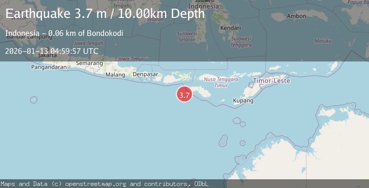
A 3.7 magnitude earthquake struck on SOUTH OF SUMBAWA, INDONESIA, at Tue, 13 Jan 2026 04:59:57 GMT. Depth: 10km. Reviewed by BMKG seismologists, this minor quake occurred at a magnitude type of m.
Magnitude
3.7
m
Source
BMKG
Intensity
-
Agency Reports
1 Sources| Source | Magnitude | Depth | Time |
|---|---|---|---|
| BMKGPrimary | 3.7 | 0 km | 1 month ago |
Earthquake Details
AutomaticEvent IDemsc_BMKG_20260113_0000067
Tsunami PotentialNo
Magnitude Typem
Nearest Places
- Tanjung Karosso57.8 km
- Tanjung Waibuku61.7 km
- Tanjung Mbulir61.9 km
- Waibuku61.9 km
- Mbulir62.3 km
Comments
Join the discussion about this event.
Latest Earthquakes
3.0Mag
Tarapaca, Chile
Time16 hours ago
Depth100.83 km
SourceVYT (Automatic)
2.1Mag
Sumbawa Region, Indonesia
Time16 hours ago
Depth10.00 km
SourceBMKG
3.3Mag
West Papua Region, Indonesia
Time16 hours ago
Depth10.00 km
SourceBMKG
2.4Mag
Java, Indonesia
Time16 hours ago
Depth14.70 km
SourceBMKG
2.2Mag
Flores Sea
Time16 hours ago
Depth28.79 km
SourceBMKG
Nearby Earthquakes
4.0Mag
SUMBAWA REGION, INDONESIA
Time9 months ago
Depth18.00 km
SourceBMKG (Automatic)
5.5Mag
SOUTH OF SUMBAWA, INDONESIA
Time16 years ago
Depth10.00 km
SourceEMSC (Automatic)
2.7Mag
South of Sumbawa, Indonesia
Time3 weeks ago
Depth10.00 km
SourceBMKG (Automatic)
2.4Mag
South of Sumbawa, Indonesia
Time6 days ago
Depth33.23 km
SourceBMKG
2.8Mag
SOUTH OF SUMBAWA, INDONESIA
Time1 month ago
Depth15.00 km
SourceBMKG (Automatic)