Earthquake Minahassa Peninsula, Sulawesi
Wed, 18 Feb 2026 14:20:27 GMT
Time1 hour ago
Location
-0.6265, 122.4103
Depth
10.6 KM
Event Summary
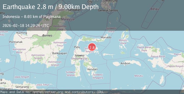
A 2.7 magnitude earthquake struck on Minahassa Peninsula, Sulawesi, at Wed, 18 Feb 2026 14:20:27 GMT. Depth: 10.574137km. Reviewed by BMKG seismologists, this minor quake occurred at a magnitude type of M.
Magnitude
2.7
M
Source
BMKG
Intensity
-
Agency Reports
1 Sources| Source | Magnitude | Depth | Time |
|---|---|---|---|
| BMKGPrimary | 2.7 | 11 km | 1 hour ago |
Earthquake Details
ManualEvent IDbmg2026dkun
Tsunami PotentialNo
Magnitude TypeM
Nearest Places
- Dulang15.9 km
- Abason16.0 km
- Lontio16.9 km
- Bungkutnyo Dulang17.0 km
- Tanjung Papagoan17.3 km
Comments
Join the discussion about this event.
Latest Earthquakes
0.6Mag
Southern Alaska
Time1 hour ago
Depth7.20 km
SourceVYT (Automatic)
3.0Mag
Tarapaca, Chile
Time1 hour ago
Depth140.38 km
SourceVYT (Automatic)
1.4Mag
Kenai Peninsula, Alaska
Time1 hour ago
Depth0.00 km
SourceVYT (Automatic)
2.8Mag
Northern Molucca Sea
Time1 hour ago
Depth17.04 km
SourceBMKG
2.4Mag
Fox Islands, Aleutian Islands, Alaska
Time1 hour ago
Depth1.22 km
SourceVYT (Automatic)
Nearby Earthquakes
2.5Mag
Minahassa Peninsula, Sulawesi
Time2 days ago
Depth7.98 km
SourceBMKG
3.0Mag
SULAWESI, INDONESIA
Time5 months ago
Depth10.00 km
SourceBMKG (Automatic)
2.0Mag
Minahassa Peninsula, Sulawesi
Time1 day ago
Depth7.87 km
SourceBMKG
5.3Mag
SULAWESI, INDONESIA
Time15 years ago
Depth15.00 km
SourceEMSC (Automatic)
5.9Mag
SULAWESI, INDONESIA
Time10 years ago
Depth40.00 km
SourceEMSC (Automatic)