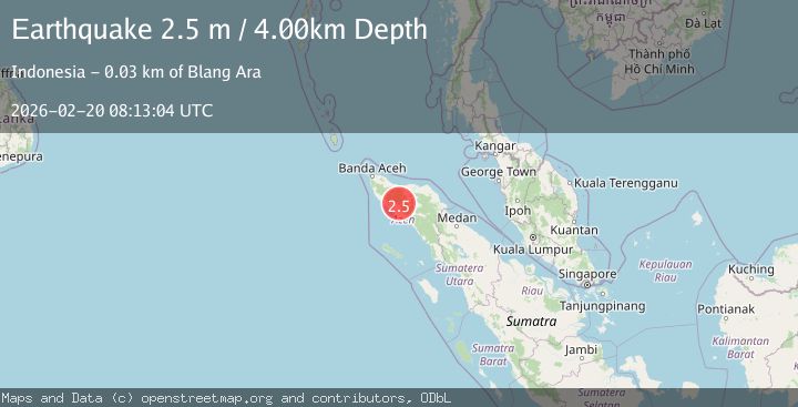
Earthquake Northern Sumatra, Indonesia
Fri, 20 Feb 2026 08:13:03 GMT
Time1 hour ago
Location
4.5800, 96.3883
Depth
10.2 KM
Event Summary
A 2.4 magnitude earthquake struck on Northern Sumatra, Indonesia, at Fri, 20 Feb 2026 08:13:03 GMT. Depth: 10.178073km. Reviewed by BMKG seismologists, this minor quake occurred at a magnitude type of M.
Magnitude
2.4
M
Source
BMKG
Intensity
-
Agency Reports
1 Sources| Source | Magnitude | Depth | Time |
|---|---|---|---|
| BMKGPrimary | 2.4 | 10 km | 1 hour ago |
Earthquake Details
ManualEvent IDbmg2026dnzk
Tsunami PotentialNo
Magnitude TypeM
Nearest Places
- Alue Baso2.3 km
- Alue Buloh2.5 km
- Alue Saya2.6 km
- Beutong Ayeuh2.8 km
- Reungguih3.3 km
Comments
Join the discussion about this event.
Latest Earthquakes
0.8Mag
5 km SW of Anza, CA
Time1 hour ago
Depth7.50 km
SourceUSGS (Automatic)
0.7Mag
7 km WNW of Cobb, CA
Time1 hour ago
Depth1.75 km
SourceUSGS (Automatic)
1.2Mag
9 km N of Banning, CA
Time1 hour ago
Depth18.03 km
SourceUSGS (Automatic)
2.1Mag
Southern California
Time1 hour ago
Depth8.54 km
SourceVYT (Automatic)
4.2Mag
VERACRUZ, MEXICO
Time1 hour ago
Depth131.00 km
SourceUNM (Automatic)
Nearby Earthquakes
5.3Mag
NORTHERN SUMATRA, INDONESIA
Time14 years ago
Depth10.00 km
SourceEMSC (Automatic)
3.0Mag
NORTHERN SUMATRA, INDONESIA
Time2 years ago
Depth10.00 km
SourceBMKG (Automatic)
3.0Mag
NORTHERN SUMATRA, INDONESIA
Time3 years ago
Depth10.00 km
SourceDJA (Automatic)
2.3Mag
Northern Sumatra, Indonesia
Time3 days ago
Depth5.22 km
SourceBMKG
4.0Mag
NORTHERN SUMATRA, INDONESIA
Time1 year ago
Depth10.00 km
SourceBMKG (Automatic)