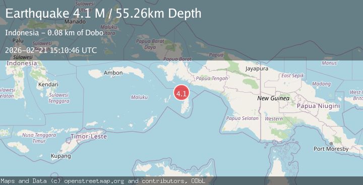
Earthquake Aru Islands Region, Indonesia
Sat, 21 Feb 2026 15:10:46 GMT
Time1 hour ago
Location
-5.0608, 134.1661
Depth
45.2 KM
Event Summary
A 3.9 magnitude earthquake struck on Aru Islands Region, Indonesia, at Sat, 21 Feb 2026 15:10:46 GMT. Depth: 45.178364km. Reviewed by BMKG seismologists, this minor quake occurred at a magnitude type of M.
Magnitude
3.9
M
Source
BMKG
Intensity
-
Agency Reports
1 Sources| Source | Magnitude | Depth | Time |
|---|---|---|---|
| BMKGPrimary | 3.9 | 45 km | 1 hour ago |
Earthquake Details
ManualEvent IDbmg2026dqis
Tsunami PotentialNo
Magnitude TypeM
Nearest Places
- 19.6 km
- 41.8 km
- 48.4 km
- 49.6 km
- 51.3 km
Comments
Join the discussion about this event.
Latest Earthquakes
2.4Mag
Papua, Indonesia
Time1 hour ago
Depth2.81 km
SourceVYT (Automatic)
1.0Mag
3 km N of The Geysers, CA
Time1 hour ago
Depth-0.19 km
SourceUSGS (Automatic)
3.9Mag
Salta, Argentina
Time1 hour ago
Depth210.82 km
SourceVYT (Automatic)
2.1Mag
Alaska Peninsula
Time1 hour ago
Depth0.61 km
SourceVYT (Automatic)
0.8Mag
Northern Territory, Australia
Time1 hour ago
Depth24.29 km
SourceVYT (Automatic)
Nearby Earthquakes
5.1Mag
KEPULAUAN ARU REGION, INDONESIA
Time20 years ago
Depth10.00 km
SourceEMSC (Automatic)
5.4Mag
KEPULAUAN ARU REGION, INDONESIA
Time16 years ago
Depth33.00 km
SourceEMSC (Automatic)
5.0Mag
Papua region, Indonesia
Time1 week ago
Depth10.00 km
SourceVYT (Automatic)
4.0Mag
NEAR S COAST OF PAPUA, INDONESIA
Time2 years ago
Depth50.00 km
SourceBMKG (Automatic)
4.9Mag
Kepulauan Aru region, Indonesia
Time4 hours ago
Depth0.00 km
SourceVYT (Automatic)