Earthquake Papua region, Indonesia
Sat, 14 Feb 2026 09:48:17 GMT
Time4 days ago
Location
-4.9198, 134.2071
Depth
10.0 KM
Event Summary
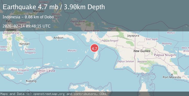
A 5.0 magnitude earthquake struck on Papua region, Indonesia, at Sat, 14 Feb 2026 09:48:17 GMT. Depth: 10km. Reviewed by VYT seismologists, this light quake occurred at a magnitude type of earthquake.
Magnitude
5.0
earthquake
Source
VYT
Intensity
-
Agency Reports
4 Sources| Source | Magnitude | Depth | Time |
|---|---|---|---|
| VYTPrimary | 5.0 | 10 km | 4 days ago |
| BMKG | 5.0 | 10 km | 4 days ago |
| NEIC | 4.7 | 10 km | 4 days ago |
| EMSC | 4.7 | 4 km | 4 days ago |
Earthquake Details
AutomaticEvent IDvyt_295nna509mk1g
Tsunami PotentialNo
Magnitude Typeearthquake
Nearest Places
- Aru Basin24.6 km
- Java Reef56.5 km
- Pulau Ngoba57.7 km
- Pulau Toba58.2 km
- Tanjung Watuleijuring60.5 km
Comments
Join the discussion about this event.
Latest Earthquakes
2.1Mag
Flores Region, Indonesia
Time3 minutes ago
Depth165.90 km
SourceBMKG
2.4Mag
Sumbawa region, Indonesia
Time4 minutes ago
Depth19.65 km
SourceVYT (Automatic)
2.1Mag
Poland
Time7 minutes ago
Depth1.95 km
SourceVYT (Automatic)
1.7Mag
2 km NW of Enterprise, Nevada
Time15 minutes ago
Depth15.89 km
SourceUSGS (Automatic)
1.3Mag
Southeastern Alaska
Time16 minutes ago
Depth7.20 km
SourceVYT (Automatic)
Nearby Earthquakes
4.0Mag
NEAR S COAST OF PAPUA, INDONESIA
Time2 years ago
Depth50.00 km
SourceBMKG (Automatic)
5.1Mag
NEAR S COAST OF PAPUA, INDONESIA
Time1 year ago
Depth10.00 km
SourceEMSC (Automatic)
5.2Mag
NEAR S COAST OF PAPUA, INDONESIA
Time10 years ago
Depth30.00 km
SourceEMSC (Automatic)
5.0Mag
NEAR S COAST OF PAPUA, INDONESIA
Time14 years ago
Depth2.00 km
SourceEMSC (Automatic)
5.0Mag
NEAR S COAST OF PAPUA, INDONESIA
Time12 years ago
Depth30.00 km
SourceEMSC (Automatic)