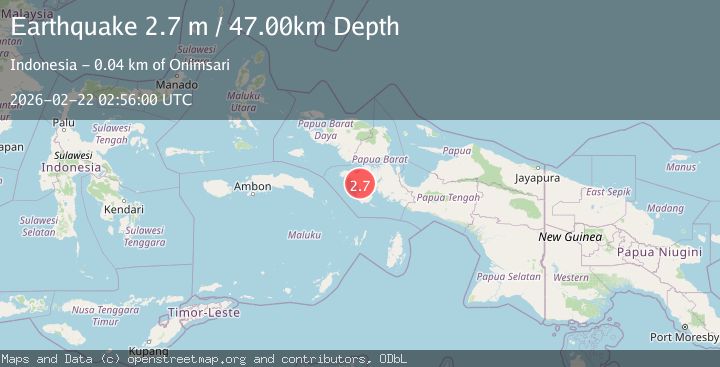
Earthquake West Papua Region, Indonesia
Sun, 22 Feb 2026 02:56:00 GMT
Time1 hour ago
Location
-3.2537, 132.9342
Depth
47.2 KM
Event Summary
A 2.7 magnitude earthquake struck on West Papua Region, Indonesia, at Sun, 22 Feb 2026 02:56:00 GMT. Depth: 47.17186km. Reviewed by BMKG seismologists, this minor quake occurred at a magnitude type of M.
Magnitude
2.7
M
Source
BMKG
Intensity
-
Agency Reports
1 Sources| Source | Magnitude | Depth | Time |
|---|---|---|---|
| BMKGPrimary | 2.7 | 47 km | 1 hour ago |
Earthquake Details
ManualEvent IDbmg2026drfz
Tsunami PotentialNo
Magnitude TypeM
Nearest Places
- 15.0 km
- 15.4 km
- 15.7 km
- 18.0 km
- 18.2 km
Comments
Join the discussion about this event.
Latest Earthquakes
2.3Mag
West Papua Region, Indonesia
Time1 hour ago
Depth11.24 km
SourceBMKG
3.2Mag
Kepulauan Tanimbar, Indonesia
Time1 hour ago
Depth218.14 km
SourceVYT (Automatic)
3.7Mag
BANDA SEA
Time1 hour ago
Depth186.00 km
SourceBMKG (Automatic)
1.6Mag
Antofagasta, Chile
Time1 hour ago
Depth35.28 km
SourceVYT (Automatic)
1.5Mag
near the coast of South Australia
Time1 hour ago
Depth10.13 km
SourceVYT (Automatic)
Nearby Earthquakes
2.6Mag
West Papua Region, Indonesia
Time1 week ago
Depth10.00 km
SourceBMKG (Automatic)
2.6Mag
PAPUA, INDONESIA
Time1 week ago
Depth10.00 km
SourceBMKG (Automatic)
2.6Mag
PAPUA, INDONESIA
Time1 month ago
Depth10.00 km
SourceBMKG (Automatic)
2.6Mag
PAPUA, INDONESIA
Time1 month ago
Depth31.00 km
SourceBMKG (Automatic)
2.9Mag
West Papua Region, Indonesia
Time3 weeks ago
Depth16.58 km
SourceBMKG (Automatic)