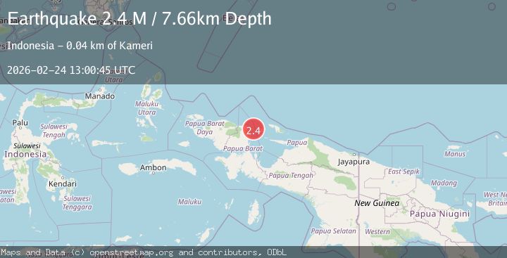
Earthquake West Papua Region, Indonesia
Tue, 24 Feb 2026 13:00:45 GMT
Time1 hour ago
Location
-0.9639, 134.4607
Depth
7.7 KM
Event Summary
A 2.4 magnitude earthquake struck on West Papua Region, Indonesia, at Tue, 24 Feb 2026 13:00:45 GMT. Depth: 7.664431km. Reviewed by BMKG seismologists, this minor quake occurred at a magnitude type of M.
Magnitude
2.4
M
Source
BMKG
Intensity
-
Agency Reports
1 Sources| Source | Magnitude | Depth | Time |
|---|---|---|---|
| BMKGPrimary | 2.4 | 8 km | 1 hour ago |
Earthquake Details
ManualEvent IDbmg2026dvqx
Tsunami PotentialNo
Magnitude TypeM
Nearest Places
- 27.4 km
- 35.8 km
- 37.6 km
- 37.9 km
- 38.0 km
Comments
Join the discussion about this event.
Latest Earthquakes
2.3Mag
Kenai Peninsula, Alaska
Time1 hour ago
Depth93.51 km
SourceVYT
3.3Mag
Fox Islands, Aleutian Islands, Alaska
Time1 hour ago
Depth0.00 km
SourceVYT (Automatic)
1.4Mag
57 km S of Whites City, New Mexico
Time1 hour ago
Depth0.00 km
SourceUSGS (Automatic)
1.0Mag
14 km ENE of Borrego Springs, CA
Time1 hour ago
Depth10.72 km
SourceUSGS (Automatic)
2.3Mag
Fox Islands, Aleutian Islands, Alaska
Time1 hour ago
Depth16.24 km
SourceVYT (Automatic)
Nearby Earthquakes
2.4Mag
West Papua Region, Indonesia
Time2 weeks ago
Depth20.30 km
SourceBMKG (Automatic)
2.5Mag
NEAR N COAST OF PAPUA, INDONESIA
Time1 day ago
Depth11.00 km
SourceBMKG (Automatic)
2.5Mag
NEAR N COAST OF PAPUA, INDONESIA
Time1 month ago
Depth10.00 km
SourceBMKG (Automatic)
3.4Mag
West Papua Region, Indonesia
Time0 months ago
Depth10.00 km
SourceBMKG (Automatic)
2.8Mag
West Papua Region, Indonesia
Time1 month ago
Depth10.00 km
SourceBMKG (Automatic)