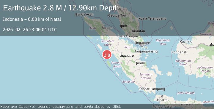
Earthquake Southern Sumatra, Indonesia
Thu, 26 Feb 2026 23:00:04 GMT
Time1 hour ago
Location
-0.0170, 98.6941
Depth
12.9 KM
Event Summary
A 2.8 magnitude earthquake struck on Southern Sumatra, Indonesia, at Thu, 26 Feb 2026 23:00:04 GMT. Depth: 12.897315km. Reviewed by BMKG seismologists, this minor quake occurred at a magnitude type of M.
Magnitude
2.8
M
Source
BMKG
Intensity
-
Agency Reports
1 Sources| Source | Magnitude | Depth | Time |
|---|---|---|---|
| BMKGPrimary | 2.8 | 13 km | 1 hour ago |
Earthquake Details
ManualEvent IDbmg2026eabs
Tsunami PotentialNo
Magnitude TypeM
Nearest Places
- 7.1 km
- 7.8 km
- 9.8 km
- 10.0 km
- 10.6 km
Comments
Join the discussion about this event.
Latest Earthquakes
1.3Mag
Alaska Peninsula
Time1 hour ago
Depth0.00 km
SourceVYT (Automatic)
3.2Mag
Celebes Sea
Time1 hour ago
Depth348.75 km
SourceVYT (Automatic)
2.6Mag
Czech Republic
Time1 hour ago
Depth1.59 km
SourceVYT (Automatic)
1.5Mag
11 km W of Templeton, CA
Time1 hour ago
Depth4.96 km
SourceUSGS (Automatic)
0.9Mag
85 km NNW of Karluk, Alaska
Time1 hour ago
Depth5.00 km
SourceUSGS (Automatic)
Nearby Earthquakes
3.3Mag
NIAS REGION, INDONESIA
Time2 months ago
Depth16.00 km
SourceBMKG (Automatic)
3.0Mag
NIAS REGION, INDONESIA
Time1 year ago
Depth10.00 km
SourceBMKG (Automatic)
2.5Mag
Southern Sumatra, Indonesia
Time3 weeks ago
Depth14.57 km
SourceBMKG (Automatic)
3.0Mag
NIAS REGION, INDONESIA
Time9 months ago
Depth25.00 km
SourceBMKG (Automatic)
5.2Mag
KEPULAUAN BATU, INDONESIA
Time13 years ago
Depth30.00 km
SourceEMSC (Automatic)