Earthquake Bali Region, Indonesia
Fri, 27 Feb 2026 23:00:36 GMT
Time1 hour ago
Location
-8.9243, 115.4098
Depth
94.0 KM
Event Summary
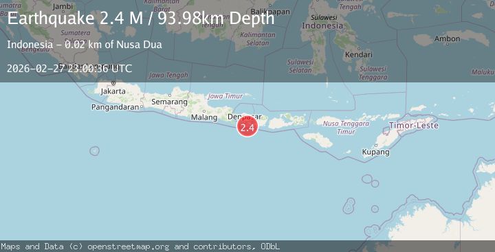
A 2.4 magnitude earthquake struck on Bali Region, Indonesia, at Fri, 27 Feb 2026 23:00:36 GMT. Depth: 93.975235km. Reviewed by BMKG seismologists, this minor quake occurred at a magnitude type of M.
Magnitude
2.4
M
Source
BMKG
Intensity
-
Agency Reports
1 Sources| Source | Magnitude | Depth | Time |
|---|---|---|---|
| BMKGPrimary | 2.4 | 94 km | 1 hour ago |
Earthquake Details
ManualEvent IDbmg2026ebxf
Tsunami PotentialNo
Magnitude TypeM
Nearest Places
- 17.4 km
- 18.5 km
- 18.5 km
- 18.7 km
- 19.0 km
Comments
Join the discussion about this event.
Latest Earthquakes
0.9Mag
Southern Alaska
Time1 hour ago
Depth4.52 km
SourceVYT (Automatic)
1.9Mag
Central Alaska
Time1 hour ago
Depth85.94 km
SourceVYT (Automatic)
2.0Mag
northwestern Russia
Time1 hour ago
Depth0.98 km
SourceVYT (Automatic)
2.6Mag
Georgia (Sak'art'velo)
Time1 hour ago
Depth0.00 km
SourceVYT (Automatic)
2.4Mag
OKLAHOMA
Time1 hour ago
Depth4.60 km
SourceOK (Automatic)
Nearby Earthquakes
4.0Mag
BALI REGION, INDONESIA
Time5 years ago
Depth81.00 km
SourceDJA (Automatic)
3.0Mag
BALI REGION, INDONESIA
Time3 years ago
Depth17.00 km
SourceDJA (Automatic)
2.6Mag
South of Bali, Indonesia
Time1 month ago
Depth158.81 km
SourceBMKG (Automatic)
5.0Mag
SOUTH OF BALI, INDONESIA
Time7 years ago
Depth80.00 km
SourceEMSC (Automatic)
2.8Mag
Bali Region, Indonesia
Time3 weeks ago
Depth94.28 km
SourceBMKG (Automatic)