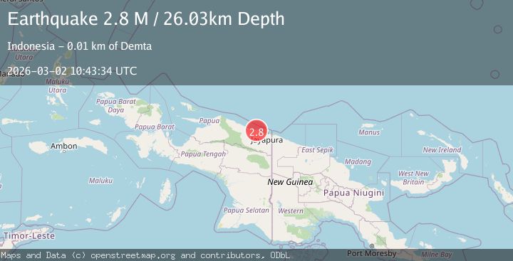
Earthquake Near North Coast of West Papua
Mon, 02 Mar 2026 10:43:34 GMT
Time1 hour ago
Location
-2.3085, 140.0592
Depth
17.0 KM
Event Summary
A 2.7 magnitude earthquake struck on Near North Coast of West Papua, at Mon, 02 Mar 2026 10:43:34 GMT. Depth: 17.017714km. Reviewed by BMKG seismologists, this minor quake occurred at a magnitude type of M.
Magnitude
2.7
M
Source
BMKG
Intensity
-
Agency Reports
1 Sources| Source | Magnitude | Depth | Time |
|---|---|---|---|
| BMKGPrimary | 2.7 | 17 km | 1 hour ago |
Earthquake Details
ManualEvent IDbmg2026eglk
Tsunami PotentialNo
Magnitude TypeM
Nearest Places
- 4.6 km
- 4.7 km
- 5.3 km
- 6.3 km
- 6.4 km
Comments
Join the discussion about this event.
Latest Earthquakes
2.5Mag
Antofagasta, Chile
Time1 hour ago
Depth159.06 km
SourceVYT (Automatic)
1.8Mag
72 km NE of Tonopah, Nevada
Time1 hour ago
Depth15.95 km
SourceUSGS (Automatic)
2.9Mag
Banda Sea
Time1 hour ago
Depth3.87 km
SourceBMKG
1.2Mag
23 km NNW of Borrego Springs, CA
Time1 hour ago
Depth2.84 km
SourceUSGS (Automatic)
2.2Mag
FRANCE
Time1 hour ago
Depth5.00 km
SourceReNaSS (Automatic)
Nearby Earthquakes
3.0Mag
NEAR N COAST OF PAPUA, INDONESIA
Time1 year ago
Depth10.00 km
SourceBMKG (Automatic)
3.0Mag
NEAR N COAST OF PAPUA, INDONESIA
Time6 months ago
Depth17.00 km
SourceBMKG (Automatic)
2.7Mag
Near North Coast of West Papua
Time2 weeks ago
Depth10.00 km
SourceBMKG
3.0Mag
NEAR N COAST OF PAPUA, INDONESIA
Time2 months ago
Depth15.00 km
SourceBMKG (Automatic)
4.0Mag
NEAR N COAST OF PAPUA, INDONESIA
Time2 years ago
Depth13.00 km
SourceBMKG (Automatic)