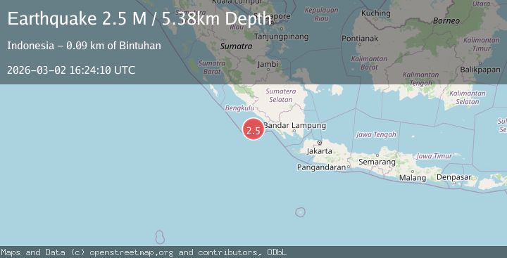
Earthquake Southern Sumatra, Indonesia
Mon, 02 Mar 2026 16:24:11 GMT
Time2 hours ago
Location
-5.1483, 102.6066
Depth
3.2 KM
Event Summary
A 2.2 magnitude earthquake struck on Southern Sumatra, Indonesia, at Mon, 02 Mar 2026 16:24:11 GMT. Depth: 3.236059km. Reviewed by BMKG seismologists, this minor quake occurred at a magnitude type of M.
Magnitude
2.2
M
Source
BMKG
Intensity
-
Agency Reports
1 Sources| Source | Magnitude | Depth | Time |
|---|---|---|---|
| BMKGPrimary | 2.2 | 3 km | 2 hours ago |
Earthquake Details
ManualEvent IDbmg2026egwq
Tsunami PotentialNo
Magnitude TypeM
Nearest Places
- 35.4 km
- 37.2 km
- 37.5 km
- 37.6 km
- 37.7 km
Comments
Join the discussion about this event.
Latest Earthquakes
4.4Mag
Banda Sea
Time1 hour ago
Depth10.00 km
SourceVYT (Automatic)
3.7Mag
northern Sumatra, Indonesia
Time2 hours ago
Depth10.50 km
SourceVYT (Automatic)
1.5Mag
NORTHERN ITALY
Time2 hours ago
Depth12.00 km
SourceOGS (Automatic)
3.0Mag
Seram, Indonesia
Time2 hours ago
Depth15.48 km
SourceBMKG
1.1Mag
15 km E of Stanton, Texas
Time2 hours ago
Depth3.37 km
SourceUSGS (Automatic)
Nearby Earthquakes
3.0Mag
SOUTHERN SUMATRA, INDONESIA
Time5 years ago
Depth10.00 km
SourceDJA (Automatic)
3.1Mag
Southern Sumatra, Indonesia
Time1 week ago
Depth10.00 km
SourceBMKG
6.0Mag
SOUTHERN SUMATRA, INDONESIA
Time15 years ago
Depth28.00 km
SourceEMSC (Automatic)
4.0Mag
SOUTHERN SUMATRA, INDONESIA
Time7 years ago
Depth21.00 km
SourceDJA (Automatic)
3.0Mag
SOUTHERN SUMATRA, INDONESIA
Time5 years ago
Depth37.00 km
SourceDJA (Automatic)