Earthquake SOUTHERN CALIFORNIA
Tue, 13 Jan 2026 18:38:15 GMT
Time1 day ago
Location
35.3485, -117.7952
Depth
4.7 KM
Event Summary
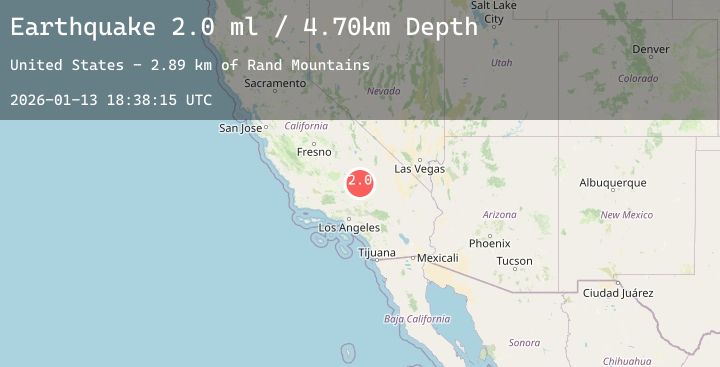
A 2.0 magnitude earthquake struck on SOUTHERN CALIFORNIA, at Tue, 13 Jan 2026 18:38:15 GMT. Depth: 4.7km. Reviewed by SCSN seismologists, this minor quake occurred at a magnitude type of ml.
Magnitude
2.0
ml
Source
SCSN
Intensity
-
Agency Reports
2 Sources| Source | Magnitude | Depth | Time |
|---|---|---|---|
| SCSNPrimary | 2.0 | 5 km | 1 day ago |
| USGS | 2.0 | 5 km | 1 day ago |
Earthquake Details
AutomaticEvent IDemsc_20260113_0000269
Tsunami PotentialNo
Magnitude Typeml
Nearest Places
- Old Garlock4.1 km
- Garlock Station (historical)4.9 km
- Mesquite Springs4.9 km
- Mesquite Canyon5.4 km
- Garlock Historical Marker6.0 km
Comments
Join the discussion about this event.
Latest Earthquakes
1.6Mag
28 km WSW of Anchor Point, Alaska
Time1 day ago
Depth91.00 km
SourceUSGS (Automatic)
3.0Mag
South of Java, Indonesia
Time1 day ago
Depth10.00 km
SourceBMKG (Automatic)
3.9Mag
WESTERN XIZANG
Time1 day ago
Depth10.00 km
SourceNDI (Automatic)
3.1Mag
South of Sumbawa, Indonesia
Time1 day ago
Depth10.00 km
SourceBMKG (Automatic)
2.5Mag
Java, Indonesia
Time1 day ago
Depth59.78 km
SourceBMKG (Automatic)