Earthquake 13 km SE of Tehachapi, CA
Mon, 12 Jan 2026 21:31:27 GMT
Time5 hours ago
Location
35.0553, -118.3480
Depth
-0.6 KM
Event Summary
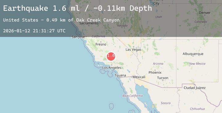
A 1.4 magnitude earthquake struck on 13 km SE of Tehachapi, CA, at Mon, 12 Jan 2026 21:31:27 GMT. Depth: -0.59km. Reviewed by USGS seismologists, this minor quake occurred at a magnitude type of ml.
Magnitude
1.4
ml
Source
USGS
Intensity
-
Agency Reports
1 Sources| Source | Magnitude | Depth | Time |
|---|---|---|---|
| USGSPrimary | 1.4 | -1 km | 5 hours ago |
Earthquake Details
AutomaticEvent IDusgs_ci41156287
Tsunami PotentialNo
Magnitude Typeml
Nearest Places
- Oak Creek Canyon1.1 km
- Cameron Valley School (historical)2.0 km
- KTPI-FM (Tehachapi)3.0 km
- Oak Creek Pass3.7 km
- Sand Canyon6.0 km
Comments
Join the discussion about this event.
Latest Earthquakes
2.8Mag
Sumbawa Region, Indonesia
Time4 hours ago
Depth7.80 km
SourceBMKG (Automatic)
2.0Mag
70 km ESE of Denali National Park, Alaska
Time4 hours ago
Depth113.00 km
SourceUSGS (Automatic)
2.7Mag
Timor Region
Time4 hours ago
Depth5.00 km
SourceBMKG (Automatic)
2.8Mag
Flores Sea
Time4 hours ago
Depth33.56 km
SourceBMKG (Automatic)
1.9Mag
51 km WNW of Toyah, Texas
Time4 hours ago
Depth0.00 km
SourceUSGS (Automatic)