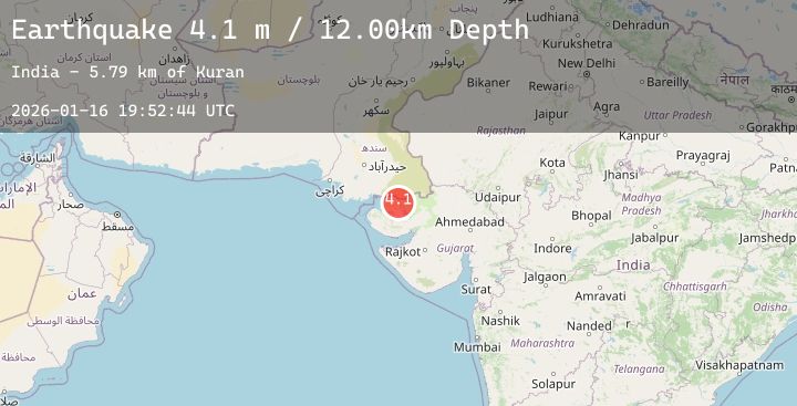
Earthquake INDIA-PAKISTAN BORDER REGION
Fri, 16 Jan 2026 19:52:44 GMT
Time3 hours ago
Location
24.0200, 69.7600
Depth
12.0 KM
Event Summary
A 4.1 magnitude earthquake struck on INDIA-PAKISTAN BORDER REGION, at Fri, 16 Jan 2026 19:52:44 GMT. Depth: 12km. Reviewed by NDI seismologists, this light quake occurred at a magnitude type of m.
Magnitude
4.1
m
Source
NDI
Intensity
-
Agency Reports
1 Sources| Source | Magnitude | Depth | Time |
|---|---|---|---|
| NDIPrimary | 4.1 | 12 km | 3 hours ago |
Earthquake Details
AutomaticEvent IDemsc_20260116_0000344
Tsunami PotentialNo
Magnitude Typem
Nearest Places
- Kuran5.8 km
- Gāinda Bet10.2 km
- Kāla Dongar11.5 km
- Bāwarla Bet14.0 km
- Pachham Island18.6 km
Comments
Join the discussion about this event.
Latest Earthquakes
2.6Mag
TARAPACA, CHILE
Time2 hours ago
Depth115.60 km
SourceCSN (Automatic)
3.0Mag
South of Sumbawa, Indonesia
Time3 hours ago
Depth10.00 km
SourceBMKG (Automatic)
1.3Mag
5 km SE of Loma Linda, CA
Time3 hours ago
Depth16.27 km
SourceUSGS (Automatic)
3.4Mag
Off West Coast of Northern Sumatra
Time3 hours ago
Depth11.55 km
SourceBMKG (Automatic)
1.1Mag
DODECANESE IS.-TURKEY BORDER REG
Time3 hours ago
Depth58.60 km
SourceAFAD (Automatic)
Nearby Earthquakes
No significant earthquakes nearby recently.