Earthquake SOUTH OF SUMBAWA, INDONESIA
Tue, 06 Jan 2026 18:58:54 GMT
Time1 month ago
Location
-10.0800, 118.7900
Depth
8.0 KM
Event Summary
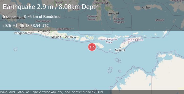
A 2.9 magnitude earthquake struck on SOUTH OF SUMBAWA, INDONESIA, at Tue, 06 Jan 2026 18:58:54 GMT. Depth: 8km. Reviewed by BMKG seismologists, this minor quake occurred at a magnitude type of m.
Magnitude
2.9
m
Source
BMKG
Intensity
-
Agency Reports
1 Sources| Source | Magnitude | Depth | Time |
|---|---|---|---|
| BMKGPrimary | 2.9 | 8 km | 1 month ago |
Earthquake Details
AutomaticEvent IDemsc_BMKG_20260106_0000358
Tsunami PotentialNo
Magnitude Typem
Nearest Places
- Tanjung Waikataku51.6 km
- Loko Waikataku51.7 km
- Tanjung Waibuku51.9 km
- Waibuku52.1 km
- Pandapia52.1 km
Comments
Join the discussion about this event.
Latest Earthquakes
2.1Mag
Antofagasta, Chile
Time2 hours ago
Depth20.26 km
SourceVYT (Automatic)
1.5Mag
48 km WNW of Tatitlek, Alaska
Time2 hours ago
Depth5.00 km
SourceUSGS (Automatic)
2.7Mag
Unimak Island region, Alaska
Time2 hours ago
Depth0.00 km
SourceVYT (Automatic)
1.6Mag
Kenai Peninsula, Alaska
Time2 hours ago
Depth78.98 km
SourceVYT (Automatic)
2.3Mag
Region Metropolitana, Chile
Time2 hours ago
Depth19.17 km
SourceVYT (Automatic)
Nearby Earthquakes
3.0Mag
SOUTH OF SUMBAWA, INDONESIA
Time3 months ago
Depth10.00 km
SourceBMKG (Automatic)
3.0Mag
SOUTH OF SUMBAWA, INDONESIA
Time5 years ago
Depth12.00 km
SourceDJA (Automatic)
2.7Mag
SOUTH OF SUMBAWA, INDONESIA
Time1 month ago
Depth23.00 km
SourceBMKG (Automatic)
2.5Mag
South of Sumbawa, Indonesia
Time1 week ago
Depth14.00 km
SourceBMKG (Automatic)
2.5Mag
SOUTH OF SUMBAWA, INDONESIA
Time1 month ago
Depth10.00 km
SourceBMKG (Automatic)