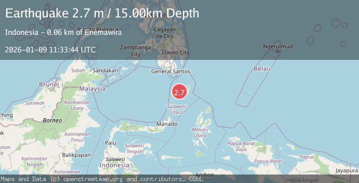
Earthquake KEPULAUAN SANGIHE, INDONESIA
Fri, 09 Jan 2026 11:33:44 GMT
Time1 month ago
Location
3.9900, 125.9500
Depth
15.0 KM
Event Summary
A 2.7 magnitude earthquake struck on KEPULAUAN SANGIHE, INDONESIA, at Fri, 09 Jan 2026 11:33:44 GMT. Depth: 15km. Reviewed by BMKG seismologists, this minor quake occurred at a magnitude type of m.
Magnitude
2.7
m
Source
BMKG
Intensity
-
Agency Reports
1 Sources| Source | Magnitude | Depth | Time |
|---|---|---|---|
| BMKGPrimary | 2.7 | 15 km | 1 month ago |
Earthquake Details
AutomaticEvent IDemsc_BMKG_20260109_0000158
Tsunami PotentialNo
Magnitude Typem
Nearest Places
- Pulau Masetang27.0 km
- Pulau Maliha28.3 km
- Pulau Saleha28.5 km
- Pulau Buang28.7 km
- Pulau Makoahe29.2 km
Comments
Join the discussion about this event.
Latest Earthquakes
3.1Mag
Halmahera, Indonesia
Time8 minutes ago
Depth113.40 km
SourceVYT (Automatic)
1.0Mag
6 km WNW of Cobb, CA
Time8 minutes ago
Depth1.71 km
SourceUSGS (Automatic)
1.5Mag
Southern Alaska
Time9 minutes ago
Depth19.90 km
SourceVYT (Automatic)
1.9Mag
British Columbia, Canada
Time18 minutes ago
Depth0.00 km
SourceVYT (Automatic)
0.7Mag
84 km S of McCarthy, Alaska
Time20 minutes ago
Depth11.40 km
SourceUSGS (Automatic)
Nearby Earthquakes
5.3Mag
KEPULAUAN SANGIHE, INDONESIA
Time4 years ago
Depth163.00 km
SourceEMSC (Automatic)
4.0Mag
KEPULAUAN SANGIHE, INDONESIA
Time4 years ago
Depth75.00 km
SourceDJA (Automatic)
5.0Mag
KEPULAUAN SANGIHE, INDONESIA
Time15 years ago
Depth163.00 km
SourceEMSC (Automatic)
3.6Mag
Talaud Islands, Indonesia
Time2 weeks ago
Depth122.10 km
SourceBMKG (Automatic)
4.1Mag
Talaud Islands, Indonesia
Time1 week ago
Depth151.32 km
SourceBMKG (Automatic)