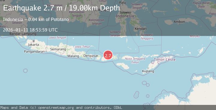
Earthquake SUMBAWA REGION, INDONESIA
Sun, 11 Jan 2026 18:53:59 GMT
Time1 month ago
Location
-8.2100, 117.7700
Depth
19.0 KM
Event Summary
A 2.7 magnitude earthquake struck on SUMBAWA REGION, INDONESIA, at Sun, 11 Jan 2026 18:53:59 GMT. Depth: 19km. Reviewed by BMKG seismologists, this minor quake occurred at a magnitude type of m.
Magnitude
2.7
m
Source
BMKG
Intensity
-
Agency Reports
1 Sources| Source | Magnitude | Depth | Time |
|---|---|---|---|
| BMKGPrimary | 2.7 | 19 km | 1 month ago |
Earthquake Details
AutomaticEvent IDemsc_BMKG_20260111_0000282
Tsunami PotentialNo
Magnitude Typem
Nearest Places
- Papekat0.8 km
- Doro Kadindi1.4 km
- Desa Kadindi1.8 km
- Kampunglapangan1.9 km
- Garuda Dua2.0 km
Comments
Join the discussion about this event.
Latest Earthquakes
2.8Mag
Sunda Strait, Indonesia
Time7 minutes ago
Depth3.61 km
SourceBMKG
3.6Mag
south of Alaska
Time7 minutes ago
Depth10.00 km
SourceVYT (Automatic)
1.2Mag
Central Alaska
Time9 minutes ago
Depth68.97 km
SourceVYT (Automatic)
1.2Mag
Washington
Time11 minutes ago
Depth0.00 km
SourceVYT (Automatic)
0.8Mag
10 km WNW of The Geysers, CA
Time18 minutes ago
Depth1.96 km
SourceUSGS (Automatic)
Nearby Earthquakes
2.0Mag
Sumbawa Region, Indonesia
Time4 days ago
Depth16.78 km
SourceBMKG
2.1Mag
Sumbawa Region, Indonesia
Time5 hours ago
Depth25.68 km
SourceBMKG
3.0Mag
SUMBAWA REGION, INDONESIA
Time2 years ago
Depth10.00 km
SourceDJA (Automatic)
2.2Mag
Sumbawa Region, Indonesia
Time3 weeks ago
Depth10.00 km
SourceBMKG (Automatic)
2.6Mag
SUMBAWA REGION, INDONESIA
Time1 month ago
Depth34.00 km
SourceBMKG (Automatic)