Earthquake MOLUCCA SEA
Tue, 13 Jan 2026 02:03:40 GMT
Time1 month ago
Location
2.9200, 126.6600
Depth
15.0 KM
Event Summary
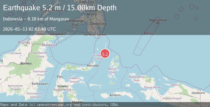
A 5.2 magnitude earthquake struck on MOLUCCA SEA, at Tue, 13 Jan 2026 02:03:40 GMT. Depth: 15km. Reviewed by BMKG seismologists, this moderate quake occurred at a magnitude type of m.
Magnitude
5.2
m
Source
BMKG
Intensity
-
Agency Reports
2 Sources| Source | Magnitude | Depth | Time |
|---|---|---|---|
| BMKGPrimary | 4.2 | 15 km | 1 month ago |
| EMSC | 5.2 | 63 km | 1 month ago |
Earthquake Details
AutomaticEvent IDemsc_BMKG_20260113_0000029
Tsunami PotentialNo
Magnitude Typem
Nearest Places
- Pulau Napumbalu83.0 km
- Tanjung Pallo91.7 km
- Taduwale92.6 km
- Tanjung Panii92.9 km
- Peret93.0 km
Comments
Join the discussion about this event.
Latest Earthquakes
2.4Mag
West Papua Region, Indonesia
Time12 minutes ago
Depth10.00 km
SourceBMKG
3.3Mag
Talaud Islands, Indonesia
Time12 minutes ago
Depth10.00 km
SourceBMKG
1.1Mag
4 km NW of The Geysers, CA
Time13 minutes ago
Depth3.39 km
SourceUSGS (Automatic)
1.0Mag
33 km WSW of Ackerly, Texas
Time13 minutes ago
Depth4.44 km
SourceUSGS (Automatic)
2.8Mag
Antofagasta, Chile
Time17 minutes ago
Depth0.00 km
SourceVYT (Automatic)
Nearby Earthquakes
4.0Mag
MOLUCCA SEA
Time1 month ago
Depth7.00 km
SourceBMKG (Automatic)
5.1Mag
MOLUCCA SEA
Time11 months ago
Depth58.30 km
SourceEMSC (Automatic)
3.0Mag
MOLUCCA SEA
Time4 years ago
Depth10.00 km
SourceDJA (Automatic)
5.1Mag
MOLUCCA SEA
Time14 years ago
Depth80.00 km
SourceEMSC (Automatic)
4.0Mag
MOLUCCA SEA
Time2 years ago
Depth10.00 km
SourceBMKG (Automatic)