Earthquake KEPULAUAN BARAT DAYA, INDONESIA
Fri, 07 Aug 2020 16:08:47 GMT
Time5 years ago
Location
-7.0900, 125.2200
Depth
516.0 KM
Event Summary
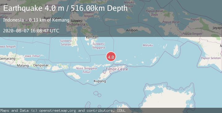
A 4.0 magnitude earthquake struck on KEPULAUAN BARAT DAYA, INDONESIA, at Fri, 07 Aug 2020 16:08:47 GMT. Depth: 516km. Reviewed by DJA seismologists, this light quake occurred at a magnitude type of m.
Magnitude
4.0
m
Source
DJA
Intensity
-
Agency Reports
1 Sources| Source | Magnitude | Depth | Time |
|---|---|---|---|
| DJAPrimary | 4.0 | 516 km | 5 years ago |
Earthquake Details
AutomaticEvent IDemsc_DJA_20200807_0000100
Tsunami PotentialNo
Magnitude Typem
Nearest Places
- Skaro Gap56.3 km
- Soekarno Seamounts63.4 km
- Skaro Kacil Seamount75.5 km
- Ina Lao Seamount78.0 km
- Tiahahu Peak78.0 km
Comments
Join the discussion about this event.
Latest Earthquakes
2.7Mag
West Papua Region, Indonesia
Time21 hours ago
Depth45.68 km
SourceBMKG
2.6Mag
Java, Indonesia
Time21 hours ago
Depth214.22 km
SourceBMKG
1.0Mag
Southeastern Alaska
Time21 hours ago
Depth0.00 km
SourceVYT (Automatic)
3.5Mag
COOK STRAIT, NEW ZEALAND
Time21 hours ago
Depth75.30 km
SourceGNS (Automatic)
2.5Mag
Seram, Indonesia
Time21 hours ago
Depth21.28 km
SourceBMKG
Nearby Earthquakes
4.0Mag
KEPULAUAN BARAT DAYA, INDONESIA
Time1 year ago
Depth540.00 km
SourceBMKG (Automatic)
4.0Mag
KEPULAUAN BARAT DAYA, INDONESIA
Time5 years ago
Depth452.00 km
SourceDJA (Automatic)
4.0Mag
BANDA SEA
Time6 months ago
Depth505.00 km
SourceBMKG (Automatic)
5.1Mag
KEPULAUAN BARAT DAYA, INDONESIA
Time15 years ago
Depth543.00 km
SourceEMSC (Automatic)
5.0Mag
KEPULAUAN BARAT DAYA, INDONESIA
Time13 years ago
Depth508.00 km
SourceEMSC (Automatic)