Earthquake MOLUCCA SEA
Sat, 10 Jul 2021 21:05:09 GMT
Time4 years ago
Location
0.7300, 126.3900
Depth
12.0 KM
Event Summary
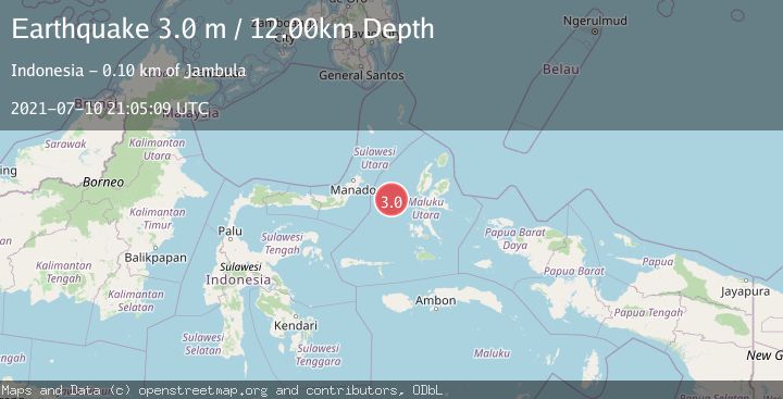
A 3.0 magnitude earthquake struck on MOLUCCA SEA, at Sat, 10 Jul 2021 21:05:09 GMT. Depth: 12km. Reviewed by DJA seismologists, this minor quake occurred at a magnitude type of m.
Magnitude
3.0
m
Source
DJA
Intensity
-
Agency Reports
1 Sources| Source | Magnitude | Depth | Time |
|---|---|---|---|
| DJAPrimary | 3.0 | 12 km | 4 years ago |
Earthquake Details
AutomaticEvent IDemsc_DJA_20210710_0000251
Tsunami PotentialNo
Magnitude Typem
Nearest Places
- Kelurahan Tifure38.0 km
- Pulau Tifore38.7 km
- Pulau Gureda39.3 km
- Kelurahan Pantai Sagu39.4 km
- Ternate Trough40.0 km
Comments
Join the discussion about this event.
Latest Earthquakes
1.1Mag
Alaska Peninsula
Time2 minutes ago
Depth0.00 km
SourceVYT (Automatic)
2.0Mag
Kenai Peninsula, Alaska
Time3 minutes ago
Depth72.27 km
SourceVYT (Automatic)
2.0Mag
Central Alaska
Time7 minutes ago
Depth216.92 km
SourceVYT (Automatic)
1.8Mag
Region Metropolitana, Chile
Time11 minutes ago
Depth14.89 km
SourceVYT (Automatic)
5.0Mag
Kepulauan Aru region, Indonesia
Time11 minutes ago
Depth0.00 km
SourceVYT (Automatic)
Nearby Earthquakes
5.7Mag
MOLUCCA SEA
Time6 years ago
Depth10.00 km
SourceEMSC (Automatic)
2.8Mag
MOLUCCA SEA
Time2 weeks ago
Depth23.00 km
SourceBMKG (Automatic)
5.1Mag
MOLUCCA SEA
Time6 years ago
Depth30.00 km
SourceEMSC (Automatic)
2.9Mag
MOLUCCA SEA
Time1 month ago
Depth27.00 km
SourceBMKG (Automatic)
3.0Mag
MOLUCCA SEA
Time3 years ago
Depth28.00 km
SourceDJA (Automatic)