Earthquake STRAIT OF GIBRALTAR
Fri, 27 Feb 2004 12:31:33 GMT
Time21 years ago
Location
35.3667, -4.2764
Depth
20.0 KM
Event Summary
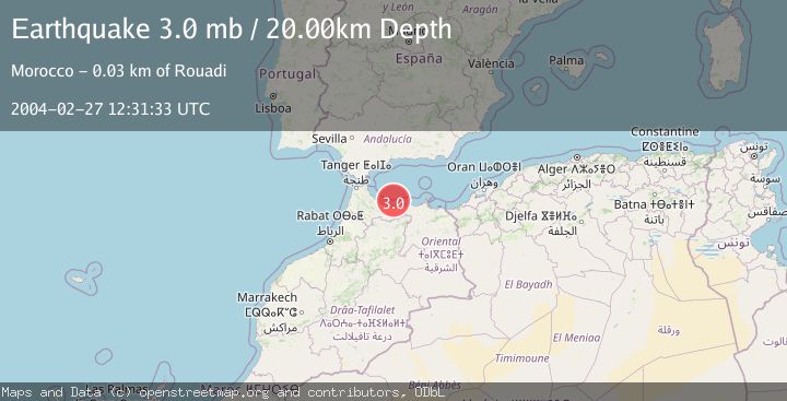
A 3.0 magnitude earthquake struck on STRAIT OF GIBRALTAR, at Fri, 27 Feb 2004 12:31:33 GMT. Depth: 20km. Reviewed by EMSC seismologists, this minor quake occurred at a magnitude type of mb.
Magnitude
3.0
mb
Source
EMSC
Intensity
-
Agency Reports
1 Sources| Source | Magnitude | Depth | Time |
|---|---|---|---|
| EMSCPrimary | 3.0 | 20 km | 21 years ago |
Earthquake Details
AutomaticEvent IDemsc_EMSC_20040227_0000035
Tsunami PotentialNo
Magnitude Typemb
Nearest Places
- 2.8 km
- 19.8 km
- 20.1 km
- 20.1 km
- 20.4 km
Comments
Join the discussion about this event.
Latest Earthquakes
2.4Mag
ISLAND OF HAWAII, HAWAII
Time8 minutes ago
Depth1.30 km
SourceHV (Automatic)
1.9Mag
9 km E of Alum Rock, CA
Time9 minutes ago
Depth5.92 km
SourceUSGS (Automatic)
2.4Mag
WESTERN TURKEY
Time19 minutes ago
Depth7.20 km
SourceKOERI (Automatic)
2.6Mag
Northern Sumatra, Indonesia
Time20 minutes ago
Depth5.00 km
SourceBMKG
1.6Mag
WESTERN TURKEY
Time24 minutes ago
Depth5.20 km
SourceAFAD (Automatic)
Nearby Earthquakes
3.0Mag
STRAIT OF GIBRALTAR
Time21 years ago
Depth10.00 km
SourceEMSC (Automatic)
3.0Mag
STRAIT OF GIBRALTAR
Time12 years ago
Depth2.00 km
SourceEMSC (Automatic)
3.0Mag
STRAIT OF GIBRALTAR
Time21 years ago
Depth2.00 km
SourceEMSC (Automatic)
3.0Mag
STRAIT OF GIBRALTAR
Time21 years ago
Depth2.00 km
SourceEMSC (Automatic)
3.0Mag
STRAIT OF GIBRALTAR
Time4 months ago
Depth7.70 km
SourceEMSC (Automatic)