Earthquake WEST OF GIBRALTAR
Wed, 26 Jan 2005 14:53:53 GMT
Time21 years ago
Location
36.7080, -9.6360
Depth
15.0 KM
Event Summary
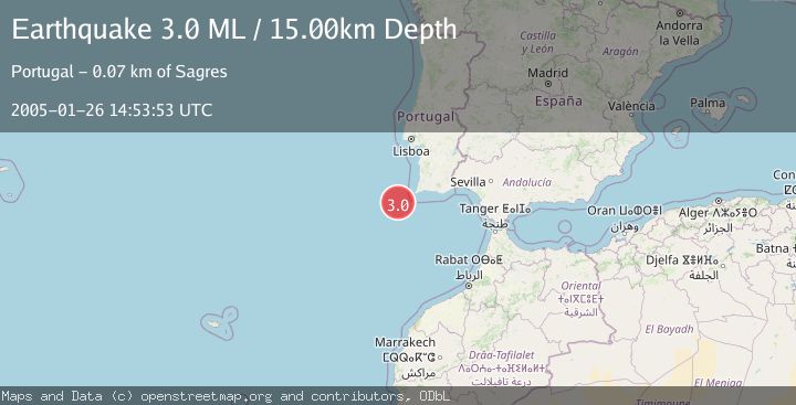
A 3.0 magnitude earthquake struck on WEST OF GIBRALTAR, at Wed, 26 Jan 2005 14:53:53 GMT. Depth: 15km. Reviewed by EMSC seismologists, this minor quake occurred at a magnitude type of ML.
Magnitude
3.0
ML
Source
EMSC
Intensity
-
Agency Reports
1 Sources| Source | Magnitude | Depth | Time |
|---|---|---|---|
| EMSCPrimary | 3.0 | 15 km | 21 years ago |
Earthquake Details
AutomaticEvent IDemsc_EMSC_20050126_0000040
Tsunami PotentialNo
Magnitude TypeML
Nearest Places
- São Vicente Canyon33.2 km
- Carlos Ribeiro Gap50.5 km
- Lagos Canyon53.0 km
- Cabo de São Vicente66.7 km
- Cabo de São Vicente Lighthouse66.8 km
Comments
Join the discussion about this event.
Latest Earthquakes
0.8Mag
8 km NW of The Geysers, CA
Time3 minutes ago
Depth1.52 km
SourceUSGS (Automatic)
3.9Mag
Coquimbo, Chile
Time7 minutes ago
Depth26.98 km
SourceVYT (Automatic)
2.7Mag
near the coast of Tarapaca, Chile
Time15 minutes ago
Depth56.52 km
SourceVYT (Automatic)
3.8Mag
Molucca Sea
Time17 minutes ago
Depth47.00 km
SourceVYT (Automatic)
1.7Mag
4 km SE of San Ramon, CA
Time17 minutes ago
Depth7.10 km
SourceUSGS (Automatic)
Nearby Earthquakes
3.0Mag
WEST OF GIBRALTAR
Time22 years ago
Depth10.00 km
SourceEMSC (Automatic)
3.0Mag
WEST OF GIBRALTAR
Time15 years ago
Depth20.00 km
SourceEMSC (Automatic)
3.0Mag
WEST OF GIBRALTAR
Time13 years ago
Depth15.00 km
SourceEMSC (Automatic)
3.0Mag
WEST OF GIBRALTAR
Time18 years ago
Depth20.00 km
SourceEMSC (Automatic)
3.0Mag
WEST OF GIBRALTAR
Time16 years ago
Depth20.00 km
SourceEMSC (Automatic)