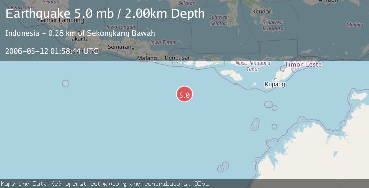
Earthquake SOUTH OF BALI, INDONESIA
Fri, 12 May 2006 01:58:44 GMT
Time19 years ago
Location
-11.3700, 115.8500
Depth
2.0 KM
Event Summary
A 5.0 magnitude earthquake struck on SOUTH OF BALI, INDONESIA, at Fri, 12 May 2006 01:58:44 GMT. Depth: 2km. Reviewed by EMSC seismologists, this moderate quake occurred at a magnitude type of mb.
Magnitude
5.0
mb
Source
EMSC
Intensity
-
Agency Reports
1 Sources| Source | Magnitude | Depth | Time |
|---|---|---|---|
| EMSCPrimary | 5.0 | 2 km | 19 years ago |
Earthquake Details
AutomaticEvent IDemsc_EMSC_20060512_0000033
Tsunami PotentialNo
Magnitude Typemb
Nearest Places
- Lombok Basin171.7 km
- Pulau Sophialouisa272.4 km
- Pulau Gilisaya273.5 km
- Gili Penginang274.5 km
- Gili Anak Ewuq274.5 km
Comments
Join the discussion about this event.
Latest Earthquakes
1.4Mag
4 km W of Lake Henshaw, CA
Time21 hours ago
Depth12.37 km
SourceUSGS (Automatic)
1.6Mag
41 km NW of Toyah, Texas
Time21 hours ago
Depth3.46 km
SourceUSGS (Automatic)
0.7Mag
6 km WNW of Cobb, CA
Time21 hours ago
Depth-0.59 km
SourceUSGS (Automatic)
1.0Mag
Southern Alaska
Time21 hours ago
Depth0.12 km
SourceVYT (Automatic)
2.1Mag
Sumbawa Region, Indonesia
Time21 hours ago
Depth21.86 km
SourceBMKG
Nearby Earthquakes
5.2Mag
SOUTH OF BALI, INDONESIA
Time10 months ago
Depth10.00 km
SourceEMSC (Automatic)
5.0Mag
SOUTH OF LOMBOK, INDONESIA
Time19 years ago
Depth10.00 km
SourceEMSC (Automatic)
6.1Mag
SOUTH OF LOMBOK, INDONESIA
Time9 years ago
Depth25.00 km
SourceEMSC (Automatic)
5.0Mag
SOUTH OF BALI, INDONESIA
Time6 years ago
Depth10.00 km
SourceEMSC (Automatic)
3.8Mag
South of Bali, Indonesia
Time1 week ago
Depth43.02 km
SourceBMKG