Earthquake SOUTH OF LOMBOK, INDONESIA
Thu, 09 Jun 2016 04:13:08 GMT
Time9 years ago
Location
-11.3800, 116.2400
Depth
25.0 KM
Event Summary
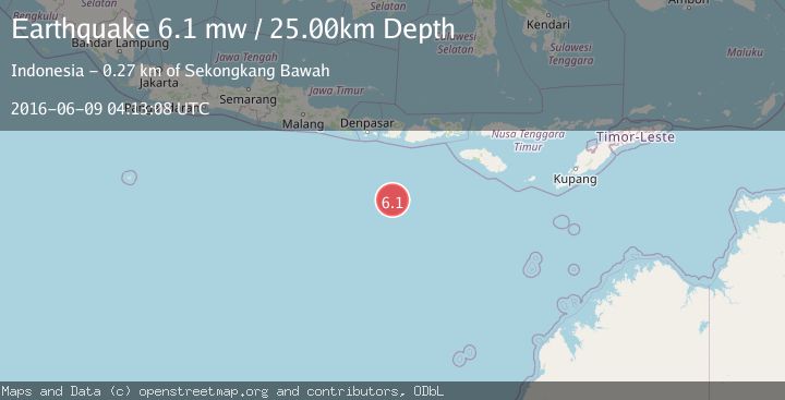
A 6.1 magnitude earthquake struck on SOUTH OF LOMBOK, INDONESIA, at Thu, 09 Jun 2016 04:13:08 GMT. Depth: 25km. Reviewed by EMSC seismologists, this strong quake occurred at a magnitude type of mw.
Magnitude
6.1
mw
Source
EMSC
Intensity
-
Agency Reports
1 Sources| Source | Magnitude | Depth | Time |
|---|---|---|---|
| EMSCPrimary | 6.1 | 25 km | 9 years ago |
Earthquake Details
AutomaticEvent IDemsc_EMSC_20160609_0000013
Tsunami PotentialNo
Magnitude Typemw
Nearest Places
- Lombok Basin174.0 km
- Tanjung Talonan266.2 km
- Tanjung Tatar266.6 km
- Teluk Senutuk266.8 km
- Tanjung Moneh266.8 km
Comments
Join the discussion about this event.
Latest Earthquakes
3.8Mag
Tarapaca, Chile
Time3 minutes ago
Depth93.51 km
SourceVYT (Automatic)
2.5Mag
Ceram Sea
Time5 minutes ago
Depth3.27 km
SourceBMKG
2.1Mag
Halmahera, Indonesia
Time8 minutes ago
Depth4.45 km
SourceBMKG
3.4Mag
Talaud Islands, Indonesia
Time11 minutes ago
Depth98.99 km
SourceBMKG
2.1Mag
Flores Region, Indonesia
Time12 minutes ago
Depth165.90 km
SourceBMKG
Nearby Earthquakes
5.0Mag
SOUTH OF LOMBOK, INDONESIA
Time19 years ago
Depth10.00 km
SourceEMSC (Automatic)
4.0Mag
SOUTH OF LOMBOK, INDONESIA
Time5 years ago
Depth10.00 km
SourceDJA (Automatic)
4.0Mag
SOUTH OF LOMBOK, INDONESIA
Time6 years ago
Depth10.00 km
SourceDJA (Automatic)
5.0Mag
SOUTH OF BALI, INDONESIA
Time19 years ago
Depth2.00 km
SourceEMSC (Automatic)
5.2Mag
SOUTH OF BALI, INDONESIA
Time10 months ago
Depth10.00 km
SourceEMSC (Automatic)