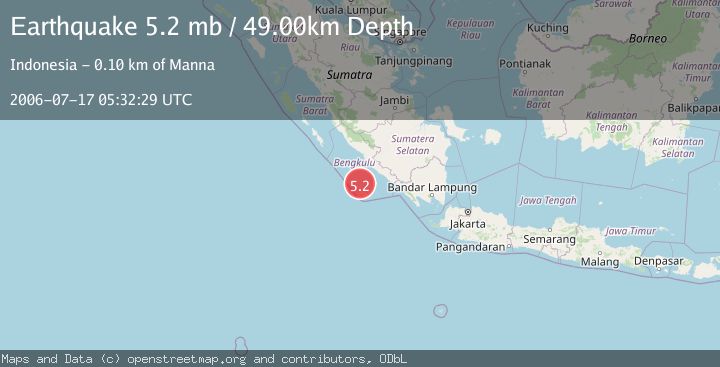
Earthquake SOUTHERN SUMATRA, INDONESIA
Mon, 17 Jul 2006 05:32:29 GMT
Time19 years ago
Location
-4.9300, 102.0900
Depth
49.0 KM
Event Summary
A 5.2 magnitude earthquake struck on SOUTHERN SUMATRA, INDONESIA, at Mon, 17 Jul 2006 05:32:29 GMT. Depth: 49km. Reviewed by EMSC seismologists, this moderate quake occurred at a magnitude type of mb.
Magnitude
5.2
mb
Source
EMSC
Intensity
-
Agency Reports
1 Sources| Source | Magnitude | Depth | Time |
|---|---|---|---|
| EMSCPrimary | 5.2 | 49 km | 19 years ago |
Earthquake Details
AutomaticEvent IDemsc_EMSC_20060717_0000059
Tsunami PotentialNo
Magnitude Typemb
Nearest Places
- Tanjung Lakoaha39.7 km
- Lakoaha39.9 km
- Sungai Hubaje40.3 km
- Kampungbaru42.0 km
- Batang Mea42.6 km
Comments
Join the discussion about this event.
Latest Earthquakes
0.3Mag
10 km WNW of The Geysers, CA
Time3 hours ago
Depth2.50 km
SourceUSGS (Automatic)
2.5Mag
Central Alaska
Time3 hours ago
Depth112.55 km
SourceVYT (Automatic)
2.3Mag
Antofagasta, Chile
Time3 hours ago
Depth58.47 km
SourceVYT (Automatic)
1.7Mag
AEGEAN SEA
Time3 hours ago
Depth7.00 km
SourceAFAD (Automatic)
1.4Mag
Southeastern Alaska
Time4 hours ago
Depth0.00 km
SourceVYT (Automatic)
Nearby Earthquakes
4.0Mag
SOUTHERN SUMATRA, INDONESIA
Time5 years ago
Depth92.00 km
SourceDJA (Automatic)
4.0Mag
SOUTHERN SUMATRA, INDONESIA
Time2 years ago
Depth10.00 km
SourceDJA (Automatic)
4.0Mag
SOUTHERN SUMATRA, INDONESIA
Time6 years ago
Depth21.00 km
SourceDJA (Automatic)
5.1Mag
SOUTHERN SUMATRA, INDONESIA
Time4 years ago
Depth30.00 km
SourceEMSC (Automatic)
3.0Mag
SOUTHERN SUMATRA, INDONESIA
Time4 months ago
Depth30.00 km
SourceBMKG (Automatic)