Earthquake Southeastern Alaska
Thu, 19 Feb 2026 01:54:02 GMT
Time1 hour ago
Location
60.5839, -139.8762
Depth
0.0 KM
Event Summary
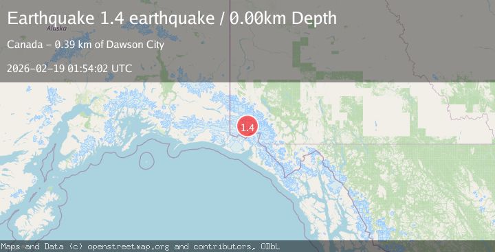
A 1.4 magnitude earthquake struck on Southeastern Alaska, at Thu, 19 Feb 2026 01:54:02 GMT. Depth: 0km. Reviewed by VYT seismologists, this minor quake occurred at a magnitude type of earthquake.
Magnitude
1.4
earthquake
Source
VYT
Intensity
-
Agency Reports
1 Sources| Source | Magnitude | Depth | Time |
|---|---|---|---|
| VYTPrimary | 1.4 | 0 km | 1 hour ago |
Earthquake Details
AutomaticEvent IDvyt_d5qs5kxziq3o
Tsunami PotentialNo
Magnitude Typeearthquake
Nearest Places
- Mount King George7.6 km
- Mount Queen Mary9.6 km
- Marker Lake10.0 km
- McArthur Peak18.6 km
- St. Elias Mountains22.5 km
Comments
Join the discussion about this event.
Latest Earthquakes
2.9Mag
Sumbawa Region, Indonesia
Time2 minutes ago
Depth53.96 km
SourceBMKG
0.8Mag
Southern Alaska
Time2 minutes ago
Depth15.50 km
SourceVYT (Automatic)
4.4Mag
North of Halmahera, Indonesia
Time5 minutes ago
Depth30.29 km
SourceBMKG
3.0Mag
Seram, Indonesia
Time6 minutes ago
Depth3.59 km
SourceBMKG
3.4Mag
Rat Islands, Aleutian Islands, Alaska
Time10 minutes ago
Depth112.18 km
SourceVYT (Automatic)
Nearby Earthquakes
3.0Mag
SOUTHERN YUKON TERRITORY, CANADA
Time2 months ago
Depth5.00 km
SourceAK (Automatic)
2.6Mag
SOUTHERN YUKON TERRITORY, CANADA
Time1 month ago
Depth5.00 km
SourceNEIC (Automatic)
3.4Mag
SOUTHERN YUKON TERRITORY, CANADA
Time1 month ago
Depth5.00 km
SourceNEIC (Automatic)
3.1Mag
SOUTHERN YUKON TERRITORY, CANADA
Time1 month ago
Depth5.00 km
SourceNEIC (Automatic)
2.5Mag
SOUTHERN YUKON TERRITORY, CANADA
Time2 weeks ago
Depth5.00 km
SourceCN (Automatic)