Earthquake MOLUCCA SEA
Thu, 31 Aug 2006 08:08:27 GMT
Time19 years ago
Location
-0.3300, 125.1700
Depth
50.0 KM
Event Summary
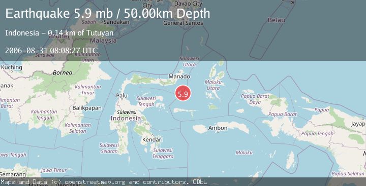
A 5.9 magnitude earthquake struck on MOLUCCA SEA, at Thu, 31 Aug 2006 08:08:27 GMT. Depth: 50km. Reviewed by EMSC seismologists, this moderate quake occurred at a magnitude type of mb.
Magnitude
5.9
mb
Source
EMSC
Intensity
-
Agency Reports
1 Sources| Source | Magnitude | Depth | Time |
|---|---|---|---|
| EMSCPrimary | 5.9 | 50 km | 19 years ago |
Earthquake Details
AutomaticEvent IDemsc_EMSC_20060831_0000042
Tsunami PotentialNo
Magnitude Typemb
Nearest Places
- Batu Mandi114.3 km
- Tanjung Flesko115.4 km
- Pulau Lampu115.8 km
- Tanjung Palureoi116.0 km
- Tanjung Payongan116.8 km
Comments
Join the discussion about this event.
Latest Earthquakes
1.0Mag
Southeastern Alaska
Time1 minute ago
Depth0.00 km
SourceVYT (Automatic)
3.5Mag
COOK STRAIT, NEW ZEALAND
Time2 minutes ago
Depth75.30 km
SourceGNS (Automatic)
2.4Mag
Seram, Indonesia
Time4 minutes ago
Depth18.42 km
SourceBMKG
2.6Mag
West Papua Region, Indonesia
Time6 minutes ago
Depth17.35 km
SourceBMKG
2.8Mag
Antofagasta, Chile
Time10 minutes ago
Depth0.00 km
SourceVYT (Automatic)
Nearby Earthquakes
5.7Mag
MOLUCCA SEA
Time19 years ago
Depth60.00 km
SourceEMSC (Automatic)
5.3Mag
MOLUCCA SEA
Time20 years ago
Depth40.00 km
SourceEMSC (Automatic)
5.0Mag
MOLUCCA SEA
Time19 years ago
Depth80.00 km
SourceEMSC (Automatic)
5.0Mag
MOLUCCA SEA
Time16 years ago
Depth80.00 km
SourceEMSC (Automatic)
5.2Mag
MOLUCCA SEA
Time1 year ago
Depth60.90 km
SourceEMSC (Automatic)