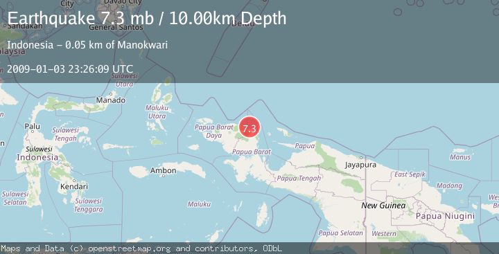
Earthquake NEAR N COAST OF PAPUA, INDONESIA
Sat, 03 Jan 2009 23:26:09 GMT
Time17 years ago
Location
-0.5800, 133.6800
Depth
10.0 KM
Event Summary
A 7.3 magnitude earthquake struck on NEAR N COAST OF PAPUA, INDONESIA, at Sat, 03 Jan 2009 23:26:09 GMT. Depth: 10km. Reviewed by EMSC seismologists, this major quake occurred at a magnitude type of mb.
Magnitude
7.3
mb
Source
EMSC
Intensity
-
Agency Reports
3 Sources| Source | Magnitude | Depth | Time |
|---|---|---|---|
| EMSCPrimary | 7.3 | 10 km | 17 years ago |
| GFZ | 5.3 | 55 km | 17 years ago |
| NEIC | 5.2 | 35 km | 17 years ago |
Earthquake Details
AutomaticEvent IDemsc_EMSC_20090103_0000123
Tsunami PotentialNo
Magnitude Typemb
Nearest Places
- Teluk Siwi16.0 km
- Tanjung Wibain17.4 km
- Sungai Warjori17.5 km
- Sungai Mangapi18.1 km
- Masni18.7 km
Comments
Join the discussion about this event.
Latest Earthquakes
1.5Mag
Java, Indonesia
Time1 minute ago
Depth22.95 km
SourceVYT (Automatic)
3.7Mag
Southern Alaska
Time10 minutes ago
Depth9.77 km
SourceVYT (Automatic)
1.3Mag
7 km NE of Coso Junction, CA
Time13 minutes ago
Depth5.86 km
SourceUSGS (Automatic)
2.2Mag
CENTRAL TURKEY
Time15 minutes ago
Depth5.00 km
SourceKOERI (Automatic)
1.1Mag
31 km WSW of Ackerly, Texas
Time19 minutes ago
Depth3.93 km
SourceUSGS (Automatic)
Nearby Earthquakes
5.0Mag
NEAR N COAST OF PAPUA, INDONESIA
Time17 years ago
Depth40.00 km
SourceEMSC (Automatic)
5.5Mag
NEAR N COAST OF PAPUA, INDONESIA
Time17 years ago
Depth20.00 km
SourceEMSC (Automatic)
6.0Mag
NEAR N COAST OF PAPUA, INDONESIA
Time17 years ago
Depth10.00 km
SourceEMSC (Automatic)
5.3Mag
NEAR N COAST OF PAPUA, INDONESIA
Time17 years ago
Depth21.00 km
SourceEMSC (Automatic)
5.0Mag
NEAR N COAST OF PAPUA, INDONESIA
Time17 years ago
Depth10.00 km
SourceEMSC (Automatic)