Earthquake Southern Alaska
Thu, 19 Feb 2026 16:33:14 GMT
Time1 hour ago
Location
60.7092, -143.0932
Depth
9.8 KM
Event Summary
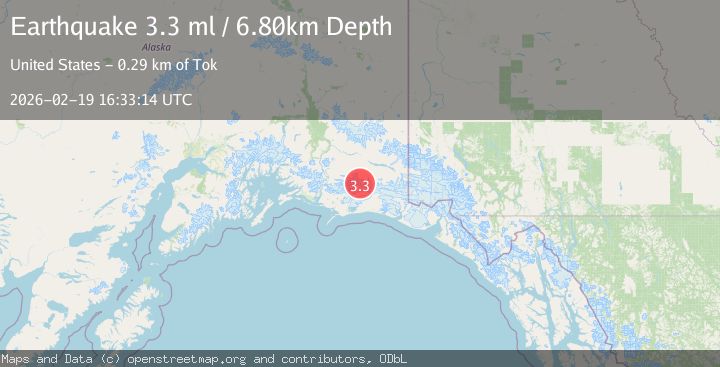
A 3.7 magnitude earthquake struck on Southern Alaska, at Thu, 19 Feb 2026 16:33:14 GMT. Depth: 9.765625km. Reviewed by VYT seismologists, this minor quake occurred at a magnitude type of earthquake.
Magnitude
3.7
earthquake
Source
VYT
Intensity
-
Agency Reports
3 Sources| Source | Magnitude | Depth | Time |
|---|---|---|---|
| VYTPrimary | 3.7 | 10 km | 1 hour ago |
| AK | 3.4 | 14 km | 1 hour ago |
| USGS | 3.3 | 7 km | 1 hour ago |
Earthquake Details
AutomaticEvent IDvyt_1wjcjwu4b6bgj
Tsunami PotentialNo
Magnitude Typeearthquake
Nearest Places
- Bremner Glacier12.9 km
- North Fork Lobe Bremner Glacier15.0 km
- Granite Creek20.2 km
- Mount Steller21.2 km
- Middle Fork Lobe Bremner Glacier21.8 km
Comments
Join the discussion about this event.
Latest Earthquakes
2.0Mag
Tarapaca, Chile
Time57 minutes ago
Depth0.00 km
SourceVYT (Automatic)
1.9Mag
Greater Los Angeles area, California
Time57 minutes ago
Depth11.47 km
SourceVYT (Automatic)
1.1Mag
Southern Alaska
Time1 hour ago
Depth17.09 km
SourceVYT (Automatic)
1.5Mag
Java, Indonesia
Time1 hour ago
Depth22.95 km
SourceVYT (Automatic)
2.3Mag
ISLAND OF HAWAII, HAWAII
Time1 hour ago
Depth32.00 km
SourceHV (Automatic)
Nearby Earthquakes
1.8Mag
Southern Alaska
Time1 day ago
Depth16.72 km
SourceVYT (Automatic)
3.6Mag
Southern Alaska
Time4 hours ago
Depth10.74 km
SourceVYT (Automatic)
0.7Mag
84 km S of McCarthy, Alaska
Time3 hours ago
Depth11.40 km
SourceUSGS (Automatic)
2.7Mag
SOUTHERN ALASKA
Time1 month ago
Depth5.00 km
SourceNEIC (Automatic)
2.1Mag
Southern Alaska
Time2 days ago
Depth18.92 km
SourceVYT (Automatic)