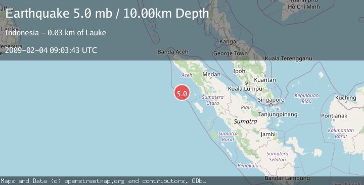
Earthquake SIMEULUE, INDONESIA
Wed, 04 Feb 2009 09:03:43 GMT
Time17 years ago
Location
2.3500, 96.1300
Depth
10.0 KM
Event Summary
A 5.0 magnitude earthquake struck on SIMEULUE, INDONESIA, at Wed, 04 Feb 2009 09:03:43 GMT. Depth: 10km. Reviewed by EMSC seismologists, this moderate quake occurred at a magnitude type of mb.
Magnitude
5.0
mb
Source
EMSC
Intensity
-
Agency Reports
1 Sources| Source | Magnitude | Depth | Time |
|---|---|---|---|
| EMSCPrimary | 5.0 | 10 km | 17 years ago |
Earthquake Details
AutomaticEvent IDemsc_EMSC_20090204_0000044
Tsunami PotentialNo
Magnitude Typemb
Nearest Places
- Pulau Mincau7.4 km
- Gampong Pulau Teupah12.2 km
- Pulau Tapah12.4 km
- Pulau Teupah12.6 km
- Pulau Sevelak13.3 km
Comments
Join the discussion about this event.
Latest Earthquakes
1.2Mag
Southern Alaska
Time3 hours ago
Depth16.72 km
SourceVYT (Automatic)
3.1Mag
northern Colombia
Time3 hours ago
Depth219.97 km
SourceVYT (Automatic)
2.2Mag
Sumbawa Region, Indonesia
Time3 hours ago
Depth15.54 km
SourceBMKG
1.3Mag
WESTERN TURKEY
Time3 hours ago
Depth9.30 km
SourceAFAD (Automatic)
4.3Mag
east of Australia
Time3 hours ago
Depth10.00 km
SourceVYT (Automatic)
Nearby Earthquakes
5.1Mag
SIMEULUE, INDONESIA
Time20 years ago
Depth30.00 km
SourceEMSC (Automatic)
5.4Mag
SIMEULUE, INDONESIA
Time14 years ago
Depth46.00 km
SourceEMSC (Automatic)
5.2Mag
SIMEULUE, INDONESIA
Time14 years ago
Depth20.00 km
SourceEMSC (Automatic)
5.2Mag
SIMEULUE, INDONESIA
Time20 years ago
Depth30.00 km
SourceEMSC (Automatic)
4.0Mag
SIMEULUE, INDONESIA
Time2 years ago
Depth16.00 km
SourceBMKG (Automatic)