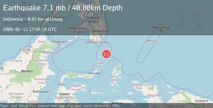
Earthquake KEPULAUAN TALAUD, INDONESIA
Wed, 11 Feb 2009 17:49:18 GMT
Time17 years ago
Location
3.9700, 126.6000
Depth
40.0 KM
Event Summary
A 7.1 magnitude earthquake struck on KEPULAUAN TALAUD, INDONESIA, at Wed, 11 Feb 2009 17:49:18 GMT. Depth: 40km. Reviewed by EMSC seismologists, this major quake occurred at a magnitude type of mb.
Magnitude
7.1
mb
Source
EMSC
Intensity
-
Agency Reports
2 Sources| Source | Magnitude | Depth | Time |
|---|---|---|---|
| EMSCPrimary | 7.1 | 10 km | 17 years ago |
| NEIC | 5.5 | 10 km | 17 years ago |
Earthquake Details
AutomaticEvent IDemsc_EMSC_20090211_0000105
Tsunami PotentialNo
Magnitude Typemb
Nearest Places
- Tanjung Toaduwowong2.1 km
- Tanjung Marawe3.8 km
- Desa Kalongan Selatan4.4 km
- Desa Talolang4.7 km
- Kecamatan Kalongan4.8 km
Comments
Join the discussion about this event.
Latest Earthquakes
0.7Mag
7 km WNW of Cobb, CA
Time4 minutes ago
Depth1.75 km
SourceUSGS (Automatic)
1.2Mag
9 km N of Banning, CA
Time6 minutes ago
Depth18.03 km
SourceUSGS (Automatic)
2.1Mag
Southern California
Time7 minutes ago
Depth8.54 km
SourceVYT (Automatic)
2.2Mag
Sweden
Time11 minutes ago
Depth0.00 km
SourceVYT (Automatic)
2.6Mag
West Papua Region, Indonesia
Time14 minutes ago
Depth14.47 km
SourceBMKG
Nearby Earthquakes
4.0Mag
KEPULAUAN TALAUD, INDONESIA
Time5 years ago
Depth10.00 km
SourceDJA (Automatic)
3.2Mag
KEPULAUAN TALAUD, INDONESIA
Time1 month ago
Depth32.00 km
SourceBMKG (Automatic)
3.0Mag
KEPULAUAN TALAUD, INDONESIA
Time5 years ago
Depth39.00 km
SourceDJA (Automatic)
3.0Mag
KEPULAUAN TALAUD, INDONESIA
Time1 month ago
Depth37.00 km
SourceBMKG (Automatic)
3.0Mag
KEPULAUAN TALAUD, INDONESIA
Time2 months ago
Depth43.00 km
SourceBMKG (Automatic)