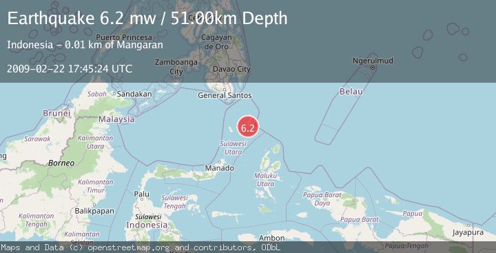
Earthquake KEPULAUAN TALAUD, INDONESIA
Sun, 22 Feb 2009 17:45:24 GMT
Time17 years ago
Location
3.7400, 126.6900
Depth
51.0 KM
Event Summary
A 6.2 magnitude earthquake struck on KEPULAUAN TALAUD, INDONESIA, at Sun, 22 Feb 2009 17:45:24 GMT. Depth: 51km. Reviewed by EMSC seismologists, this strong quake occurred at a magnitude type of mw.
Magnitude
6.2
mw
Source
EMSC
Intensity
-
Agency Reports
1 Sources| Source | Magnitude | Depth | Time |
|---|---|---|---|
| EMSCPrimary | 6.2 | 51 km | 17 years ago |
Earthquake Details
AutomaticEvent IDemsc_EMSC_20090222_0000088
Tsunami PotentialNo
Magnitude Typemw
Nearest Places
- Tanjung Lalawang7.9 km
- Tanjung Toade8.3 km
- Desa Bitunuris Selatan9.0 km
- Bulude9.0 km
- Pangeran9.5 km
Comments
Join the discussion about this event.
Latest Earthquakes
0.7Mag
7 km WNW of Cobb, CA
Time4 minutes ago
Depth1.75 km
SourceUSGS (Automatic)
1.2Mag
9 km N of Banning, CA
Time6 minutes ago
Depth18.03 km
SourceUSGS (Automatic)
2.1Mag
Southern California
Time7 minutes ago
Depth8.54 km
SourceVYT (Automatic)
2.2Mag
Sweden
Time11 minutes ago
Depth0.00 km
SourceVYT (Automatic)
2.6Mag
West Papua Region, Indonesia
Time14 minutes ago
Depth14.47 km
SourceBMKG
Nearby Earthquakes
5.3Mag
KEPULAUAN TALAUD, INDONESIA
Time15 years ago
Depth53.00 km
SourceEMSC (Automatic)
6.0Mag
KEPULAUAN TALAUD, INDONESIA
Time4 years ago
Depth40.00 km
SourceEMSC (Automatic)
5.1Mag
KEPULAUAN TALAUD, INDONESIA
Time7 years ago
Depth10.00 km
SourceEMSC (Automatic)
3.9Mag
KEPULAUAN TALAUD, INDONESIA
Time1 month ago
Depth38.00 km
SourceBMKG (Automatic)
5.1Mag
KEPULAUAN TALAUD, INDONESIA
Time3 years ago
Depth51.00 km
SourceEMSC (Automatic)