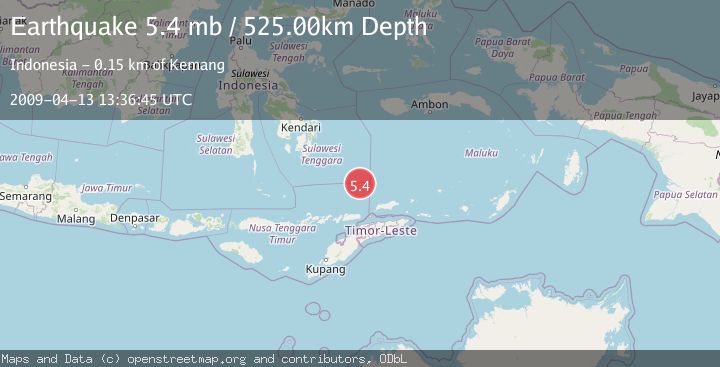
Earthquake BANDA SEA
Mon, 13 Apr 2009 13:36:45 GMT
Time16 years ago
Location
-6.8300, 125.1300
Depth
525.0 KM
Event Summary
A 5.4 magnitude earthquake struck on BANDA SEA, at Mon, 13 Apr 2009 13:36:45 GMT. Depth: 525km. Reviewed by EMSC seismologists, this moderate quake occurred at a magnitude type of mb.
Magnitude
5.4
mb
Source
EMSC
Intensity
-
Agency Reports
1 Sources| Source | Magnitude | Depth | Time |
|---|---|---|---|
| EMSCPrimary | 5.4 | 525 km | 16 years ago |
Earthquake Details
AutomaticEvent IDemsc_EMSC_20090413_0000053
Tsunami PotentialNo
Magnitude Typemb
Nearest Places
- Skaro Gap26.7 km
- Soekarno Seamounts33.9 km
- Ina Lao Seamount51.4 km
- Tiahahu Peak51.4 km
- Skaro Kacil Seamount52.1 km
Comments
Join the discussion about this event.
Latest Earthquakes
1.4Mag
Kenai Peninsula, Alaska
Time10 hours ago
Depth1.95 km
SourceVYT (Automatic)
3.1Mag
Northern Sumatra, Indonesia
Time10 hours ago
Depth14.69 km
SourceBMKG
1.9Mag
Channel Islands region, California
Time10 hours ago
Depth2.81 km
SourceVYT (Automatic)
3.3Mag
Southern Alaska
Time10 hours ago
Depth13.06 km
SourceVYT (Automatic)
1.9Mag
Southern Yukon Territory, Canada
Time10 hours ago
Depth0.00 km
SourceVYT (Automatic)
Nearby Earthquakes
3.9Mag
Banda Sea
Time2 weeks ago
Depth509.49 km
SourceBMKG (Automatic)
6.3Mag
BANDA SEA
Time6 years ago
Depth567.00 km
SourceEMSC (Automatic)
5.4Mag
BANDA SEA
Time19 years ago
Depth500.00 km
SourceEMSC (Automatic)
5.4Mag
BANDA SEA
Time6 months ago
Depth517.50 km
SourceEMSC (Automatic)
5.0Mag
BANDA SEA
Time1 year ago
Depth510.00 km
SourceEMSC (Automatic)