Earthquake PHILIPPINE ISLANDS REGION
Wed, 13 Jan 2010 07:55:00 GMT
Time16 years ago
Location
5.2200, 127.2600
Depth
118.0 KM
Event Summary
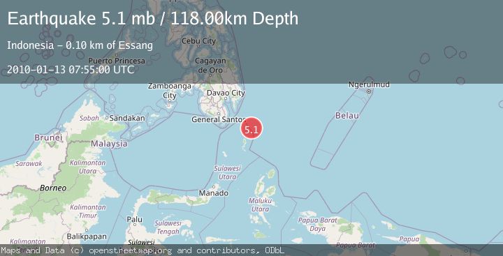
A 5.1 magnitude earthquake struck on PHILIPPINE ISLANDS REGION, at Wed, 13 Jan 2010 07:55:00 GMT. Depth: 118km. Reviewed by EMSC seismologists, this moderate quake occurred at a magnitude type of mb.
Magnitude
5.1
mb
Source
EMSC
Intensity
-
Agency Reports
1 Sources| Source | Magnitude | Depth | Time |
|---|---|---|---|
| EMSCPrimary | 5.1 | 118 km | 16 years ago |
Earthquake Details
AutomaticEvent IDemsc_EMSC_20100113_0000038
Tsunami PotentialNo
Magnitude Typemb
Nearest Places
- Pulau Garat51.8 km
- Desa Marampit53.3 km
- Desa Marampit Timur53.4 km
- Desa Dampulis53.6 km
- Kecamatan Nanusa54.1 km
Comments
Join the discussion about this event.
Latest Earthquakes
3.2Mag
Croatia region
Time8 minutes ago
Depth10.00 km
SourceVYT (Automatic)
3.6Mag
Serbia
Time8 minutes ago
Depth688.35 km
SourceVYT (Automatic)
2.0Mag
AZORES ISLANDS REGION
Time9 minutes ago
Depth10.40 km
SourcePDA (Automatic)
3.1Mag
NORTH ISLAND OF NEW ZEALAND
Time9 minutes ago
Depth204.40 km
SourceGNS (Automatic)
2.2Mag
Andreanof Islands, Aleutian Islands, Alaska
Time13 minutes ago
Depth130.98 km
SourceVYT (Automatic)
Nearby Earthquakes
5.0Mag
PHILIPPINE ISLANDS REGION
Time15 years ago
Depth117.00 km
SourceEMSC (Automatic)
3.0Mag
PHILIPPINE ISLANDS REGION
Time1 year ago
Depth35.00 km
SourcePIVS (Automatic)
3.2Mag
PHILIPPINE ISLANDS REGION
Time1 month ago
Depth14.00 km
SourcePIVS (Automatic)
5.2Mag
PHILIPPINE ISLANDS REGION
Time16 years ago
Depth148.00 km
SourceEMSC (Automatic)
3.0Mag
PHILIPPINE ISLANDS REGION
Time4 years ago
Depth8.00 km
SourcePIVS (Automatic)