Earthquake SOUTH OF FIJI ISLANDS
Sun, 07 Feb 2010 23:22:54 GMT
Time16 years ago
Location
-23.3000, -179.8100
Depth
538.0 KM
Event Summary
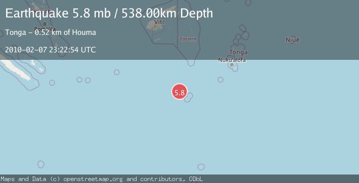
A 5.8 magnitude earthquake struck on SOUTH OF FIJI ISLANDS, at Sun, 07 Feb 2010 23:22:54 GMT. Depth: 538km. Reviewed by EMSC seismologists, this moderate quake occurred at a magnitude type of mb.
Magnitude
5.8
mb
Source
EMSC
Intensity
-
Agency Reports
1 Sources| Source | Magnitude | Depth | Time |
|---|---|---|---|
| EMSCPrimary | 5.8 | 536 km | 16 years ago |
Earthquake Details
AutomaticEvent IDemsc_EMSC_20100207_0000049
Tsunami PotentialNo
Magnitude Typemb
Nearest Places
- North Minerva Reef96.8 km
- South Minerva Reef98.5 km
- Herald Bight98.5 km
- Minerva Reefs101.7 km
- Naicibaciba Rock270.4 km
Comments
Join the discussion about this event.
Latest Earthquakes
2.8Mag
West Papua Region, Indonesia
Time3 minutes ago
Depth34.12 km
SourceBMKG
2.6Mag
Java, Indonesia
Time13 minutes ago
Depth214.22 km
SourceBMKG
1.0Mag
Southeastern Alaska
Time14 minutes ago
Depth0.00 km
SourceVYT (Automatic)
3.5Mag
COOK STRAIT, NEW ZEALAND
Time15 minutes ago
Depth75.30 km
SourceGNS (Automatic)
2.5Mag
Seram, Indonesia
Time16 minutes ago
Depth21.28 km
SourceBMKG
Nearby Earthquakes
6.2Mag
SOUTH OF FIJI ISLANDS
Time17 years ago
Depth564.00 km
SourceEMSC (Automatic)
5.0Mag
SOUTH OF FIJI ISLANDS
Time17 years ago
Depth557.00 km
SourceEMSC (Automatic)
6.3Mag
SOUTH OF FIJI ISLANDS
Time15 years ago
Depth546.00 km
SourceEMSC (Automatic)
5.2Mag
SOUTH OF FIJI ISLANDS
Time17 years ago
Depth494.00 km
SourceEMSC (Automatic)
5.6Mag
SOUTH OF FIJI ISLANDS
Time7 months ago
Depth539.20 km
SourceEMSC (Automatic)