Earthquake KEPULAUAN BABAR, INDONESIA
Sat, 17 Apr 2010 16:00:23 GMT
Time15 years ago
Location
-7.0300, 129.4700
Depth
163.0 KM
Event Summary
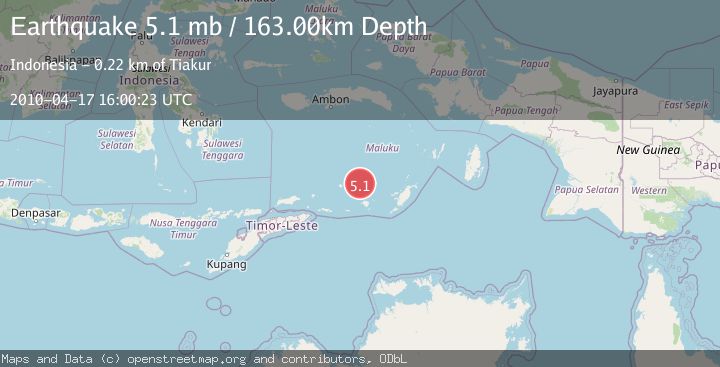
A 5.1 magnitude earthquake struck on KEPULAUAN BABAR, INDONESIA, at Sat, 17 Apr 2010 16:00:23 GMT. Depth: 163km. Reviewed by EMSC seismologists, this moderate quake occurred at a magnitude type of mb.
Magnitude
5.1
mb
Source
EMSC
Intensity
-
Agency Reports
1 Sources| Source | Magnitude | Depth | Time |
|---|---|---|---|
| EMSCPrimary | 5.1 | 163 km | 15 years ago |
Earthquake Details
AutomaticEvent IDemsc_EMSC_20100417_0000039
Tsunami PotentialNo
Magnitude Typemb
Nearest Places
- Damar Ridge22.1 km
- Tanjung Sifanandrierna30.2 km
- Wotai30.8 km
- Bumai31.3 km
- Pulau Nila32.6 km
Comments
Join the discussion about this event.
Latest Earthquakes
1.2Mag
Central Alaska
Time15 hours ago
Depth68.97 km
SourceVYT (Automatic)
1.2Mag
Washington
Time15 hours ago
Depth0.00 km
SourceVYT (Automatic)
0.8Mag
10 km WNW of The Geysers, CA
Time15 hours ago
Depth1.96 km
SourceUSGS (Automatic)
2.4Mag
Sumbawa region, Indonesia
Time15 hours ago
Depth111.45 km
SourceVYT (Automatic)
2.3Mag
NORTHERN CALIFORNIA
Time15 hours ago
Depth2.90 km
SourceNC (Automatic)
Nearby Earthquakes
3.8Mag
Banda Sea
Time1 week ago
Depth203.39 km
SourceBMKG (Automatic)
5.1Mag
KEPULAUAN BABAR, INDONESIA
Time7 years ago
Depth132.00 km
SourceEMSC (Automatic)
5.6Mag
KEPULAUAN BABAR, INDONESIA
Time2 years ago
Depth130.00 km
SourceEMSC (Automatic)
5.3Mag
KEPULAUAN BABAR, INDONESIA
Time2 years ago
Depth138.00 km
SourceEMSC (Automatic)
4.0Mag
KEPULAUAN BABAR, INDONESIA
Time4 years ago
Depth150.00 km
SourceNEIC (Automatic)