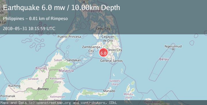
Earthquake MORO GULF, MINDANAO, PHILIPPINES
Mon, 31 May 2010 10:15:59 GMT
Time15 years ago
Location
6.9900, 123.9800
Depth
10.0 KM
Event Summary
A 6.0 magnitude earthquake struck on MORO GULF, MINDANAO, PHILIPPINES, at Mon, 31 May 2010 10:15:59 GMT. Depth: 10km. Reviewed by EMSC seismologists, this strong quake occurred at a magnitude type of mw.
Magnitude
6.0
mw
Source
EMSC
Intensity
-
Agency Reports
1 Sources| Source | Magnitude | Depth | Time |
|---|---|---|---|
| EMSCPrimary | 6.0 | 10 km | 15 years ago |
Earthquake Details
AutomaticEvent IDemsc_EMSC_20100531_0000022
Tsunami PotentialNo
Magnitude Typemw
Nearest Places
- Nalcan Creek1.0 km
- Palampio1.1 km
- Nalcan1.1 km
- Kinimi-nalkan Beach2.5 km
- Lugong Point3.2 km
Comments
Join the discussion about this event.
Latest Earthquakes
2.3Mag
Poland
Time8 hours ago
Depth0.49 km
SourceVYT (Automatic)
1.7Mag
Java, Indonesia
Time8 hours ago
Depth5.98 km
SourceVYT (Automatic)
2.5Mag
SPAIN
Time8 hours ago
Depth2.90 km
SourceIGN (Automatic)
2.5Mag
West Papua Region, Indonesia
Time8 hours ago
Depth12.37 km
SourceBMKG
2.6Mag
Antofagasta, Chile
Time8 hours ago
Depth116.33 km
SourceVYT (Automatic)
Nearby Earthquakes
3.0Mag
MORO GULF, MINDANAO, PHILIPPINES
Time4 years ago
Depth3.00 km
SourcePIVS (Automatic)
5.8Mag
MORO GULF, MINDANAO, PHILIPPINES
Time3 years ago
Depth20.00 km
SourceEMSC (Automatic)
1.8Mag
Mindanao, Philippines
Time3 weeks ago
Depth33.00 km
SourceMAN (Automatic)
5.9Mag
MORO GULF, MINDANAO, PHILIPPINES
Time7 years ago
Depth552.00 km
SourceEMSC (Automatic)
3.0Mag
MORO GULF, MINDANAO, PHILIPPINES
Time1 year ago
Depth32.00 km
SourcePIVS (Automatic)