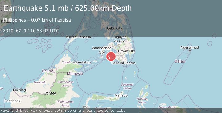
Earthquake MORO GULF, MINDANAO, PHILIPPINES
Mon, 12 Jul 2010 16:53:07 GMT
Time15 years ago
Location
6.6500, 123.4100
Depth
625.0 KM
Event Summary
A 5.1 magnitude earthquake struck on MORO GULF, MINDANAO, PHILIPPINES, at Mon, 12 Jul 2010 16:53:07 GMT. Depth: 625km. Reviewed by EMSC seismologists, this moderate quake occurred at a magnitude type of mb.
Magnitude
5.1
mb
Source
EMSC
Intensity
-
Agency Reports
1 Sources| Source | Magnitude | Depth | Time |
|---|---|---|---|
| EMSCPrimary | 5.1 | 625 km | 15 years ago |
Earthquake Details
AutomaticEvent IDemsc_EMSC_20100712_0000038
Tsunami PotentialNo
Magnitude Typemb
Nearest Places
- 50.4 km
- 60.2 km
- 61.8 km
- 62.6 km
- 63.4 km
Comments
Join the discussion about this event.
Latest Earthquakes
2.2Mag
Poland
Time4 minutes ago
Depth0.00 km
SourceVYT (Automatic)
1.7Mag
Tarapaca, Chile
Time5 minutes ago
Depth94.24 km
SourceVYT (Automatic)
1.2Mag
Kenai Peninsula, Alaska
Time5 minutes ago
Depth0.00 km
SourceVYT (Automatic)
2.2Mag
southern Quebec, Canada
Time17 minutes ago
Depth17.70 km
SourceVYT (Automatic)
1.8Mag
15 km S of Fern Forest, Hawaii
Time19 minutes ago
Depth-0.68 km
SourceUSGS (Automatic)
Nearby Earthquakes
5.1Mag
MORO GULF, MINDANAO, PHILIPPINES
Time15 years ago
Depth632.00 km
SourceEMSC (Automatic)
6.5Mag
MORO GULF, MINDANAO, PHILIPPINES
Time15 years ago
Depth616.00 km
SourceEMSC (Automatic)
5.3Mag
Mindanao, Philippines
Time3 weeks ago
Depth16.19 km
SourceBMKG (Automatic)
7.3Mag
MORO GULF, MINDANAO, PHILIPPINES
Time15 years ago
Depth600.00 km
SourceEMSC (Automatic)
6.5Mag
MORO GULF, MINDANAO, PHILIPPINES
Time16 years ago
Depth628.00 km
SourceEMSC (Automatic)