Earthquake KEPULAUAN KAI, INDONESIA
Wed, 29 Sep 2010 18:00:53 GMT
Time15 years ago
Location
-5.3700, 133.7600
Depth
30.0 KM
Event Summary
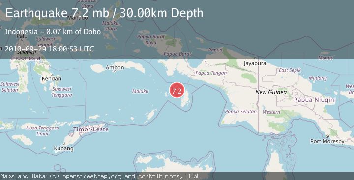
A 7.2 magnitude earthquake struck on KEPULAUAN KAI, INDONESIA, at Wed, 29 Sep 2010 18:00:53 GMT. Depth: 30km. Reviewed by EMSC seismologists, this major quake occurred at a magnitude type of mb.
Magnitude
7.2
mb
Source
EMSC
Intensity
-
Agency Reports
1 Sources| Source | Magnitude | Depth | Time |
|---|---|---|---|
| EMSCPrimary | 7.2 | 10 km | 15 years ago |
Earthquake Details
AutomaticEvent IDemsc_EMSC_20100929_0000045
Tsunami PotentialNo
Magnitude Typemb
Nearest Places
- Aru Basin49.0 km
- Java Reef55.4 km
- Pulau Wasir58.5 km
- Wasir59.7 km
- Tanjung Tutupano60.7 km
Comments
Join the discussion about this event.
Latest Earthquakes
1.7Mag
western Texas
Time3 minutes ago
Depth3.42 km
SourceVYT (Automatic)
3.5Mag
Seram, Indonesia
Time5 minutes ago
Depth0.00 km
SourceVYT (Automatic)
1.6Mag
54 km WNW of Toyah, Texas
Time11 minutes ago
Depth0.00 km
SourceUSGS (Automatic)
2.2Mag
West Papua Region, Indonesia
Time12 minutes ago
Depth26.69 km
SourceBMKG
1.2Mag
WESTERN TURKEY
Time13 minutes ago
Depth7.00 km
SourceAFAD (Automatic)
Nearby Earthquakes
5.4Mag
KEPULAUAN KAI, INDONESIA
Time16 years ago
Depth10.00 km
SourceEMSC (Automatic)
5.1Mag
KEPULAUAN KAI, INDONESIA
Time3 months ago
Depth6.50 km
SourceEMSC (Automatic)
5.3Mag
KEPULAUAN KAI, INDONESIA
Time14 years ago
Depth61.00 km
SourceEMSC (Automatic)
3.0Mag
KEPULAUAN KAI, INDONESIA
Time5 years ago
Depth10.00 km
SourceDJA (Automatic)
6.0Mag
KEPULAUAN KAI, INDONESIA
Time15 years ago
Depth10.00 km
SourceEMSC (Automatic)