Earthquake WEST OF GIBRALTAR
Wed, 26 Jan 2011 23:44:29 GMT
Time15 years ago
Location
36.9609, -9.5392
Depth
30.0 KM
Event Summary
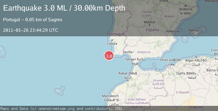
A 3.0 magnitude earthquake struck on WEST OF GIBRALTAR, at Wed, 26 Jan 2011 23:44:29 GMT. Depth: 30km. Reviewed by EMSC seismologists, this minor quake occurred at a magnitude type of ML.
Magnitude
3.0
ML
Source
EMSC
Intensity
-
Agency Reports
1 Sources| Source | Magnitude | Depth | Time |
|---|---|---|---|
| EMSCPrimary | 3.0 | 30 km | 15 years ago |
Earthquake Details
AutomaticEvent IDemsc_EMSC_20110126_0000058
Tsunami PotentialNo
Magnitude TypeML
Nearest Places
- São Vicente Canyon10.9 km
- Cabo de São Vicente48.6 km
- Cabo de São Vicente Lighthouse48.7 km
- Pontal dos Corvos49.1 km
- Pedra das Gaivotas49.2 km
Comments
Join the discussion about this event.
Latest Earthquakes
1.9Mag
Poland
Time15 minutes ago
Depth10.01 km
SourceVYT (Automatic)
1.6Mag
10 km W of Pine Valley, CA
Time23 minutes ago
Depth16.88 km
SourceUSGS (Automatic)
2.4Mag
West Papua Region, Indonesia
Time23 minutes ago
Depth10.00 km
SourceBMKG
4.5Mag
Tarapaca, Chile
Time28 minutes ago
Depth128.42 km
SourceVYT (Automatic)
2.3Mag
PUERTO RICO
Time34 minutes ago
Depth15.50 km
SourcePR (Automatic)
Nearby Earthquakes
3.0Mag
WEST OF GIBRALTAR
Time21 years ago
Depth10.00 km
SourceEMSC (Automatic)
3.0Mag
PORTUGAL
Time21 years ago
Depth30.00 km
SourceEMSC (Automatic)
3.0Mag
WEST OF GIBRALTAR
Time22 years ago
Depth10.00 km
SourceEMSC (Automatic)
3.0Mag
WEST OF GIBRALTAR
Time14 years ago
Depth60.00 km
SourceEMSC (Automatic)
3.0Mag
WEST OF GIBRALTAR
Time15 years ago
Depth20.00 km
SourceEMSC (Automatic)