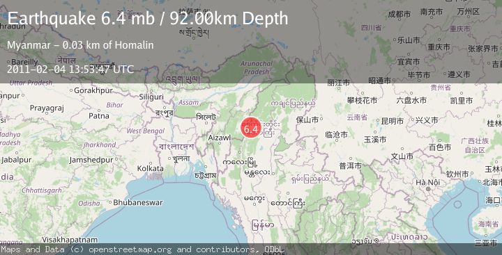
Earthquake MYANMAR-INDIA BORDER REGION
Fri, 04 Feb 2011 13:53:47 GMT
Time15 years ago
Location
24.6400, 94.7200
Depth
92.0 KM
Event Summary
A 6.4 magnitude earthquake struck on MYANMAR-INDIA BORDER REGION, at Fri, 04 Feb 2011 13:53:47 GMT. Depth: 92km. Reviewed by EMSC seismologists, this strong quake occurred at a magnitude type of mb.
Magnitude
6.4
mb
Source
EMSC
Intensity
-
Agency Reports
1 Sources| Source | Magnitude | Depth | Time |
|---|---|---|---|
| EMSCPrimary | 6.4 | 92 km | 15 years ago |
Earthquake Details
AutomaticEvent IDemsc_EMSC_20110204_0000031
Tsunami PotentialNo
Magnitude Typemb
Nearest Places
- 1.1 km
- 1.1 km
- 2.1 km
- 3.5 km
- 4.6 km
Comments
Join the discussion about this event.
Latest Earthquakes
2.7Mag
Antofagasta, Chile
Time2 minutes ago
Depth128.05 km
SourceVYT (Automatic)
1.2Mag
7 km NNE of Borrego Springs, CA
Time7 minutes ago
Depth9.86 km
SourceUSGS (Automatic)
1.4Mag
CENTRAL TURKEY
Time10 minutes ago
Depth7.00 km
SourceAFAD (Automatic)
0.6Mag
8 km WNW of Cobb, CA
Time11 minutes ago
Depth2.00 km
SourceUSGS (Automatic)
3.6Mag
Molucca Sea
Time13 minutes ago
Depth103.03 km
SourceVYT (Automatic)
Nearby Earthquakes
5.8Mag
MYANMAR-INDIA BORDER REGION
Time20 years ago
Depth33.00 km
SourceEMSC (Automatic)
5.4Mag
MYANMAR-INDIA BORDER REGION
Time11 months ago
Depth59.50 km
SourceEMSC (Automatic)
5.0Mag
MYANMAR-INDIA BORDER REGION
Time11 years ago
Depth100.00 km
SourceEMSC (Automatic)
3.9Mag
MYANMAR-INDIA BORDER REGION
Time2 weeks ago
Depth85.00 km
SourceNDI (Automatic)
3.0Mag
MYANMAR-INDIA BORDER REGION
Time5 years ago
Depth60.00 km
SourceNDI (Automatic)