Earthquake SOUTHERN SUMATRA, INDONESIA
Fri, 11 Oct 2013 13:12:57 GMT
Time12 years ago
Location
-5.9400, 102.9900
Depth
35.0 KM
Event Summary
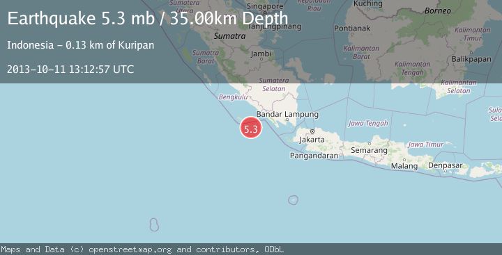
A 5.3 magnitude earthquake struck on SOUTHERN SUMATRA, INDONESIA, at Fri, 11 Oct 2013 13:12:57 GMT. Depth: 35km. Reviewed by EMSC seismologists, this moderate quake occurred at a magnitude type of mb.
Magnitude
5.3
mb
Source
EMSC
Intensity
-
Agency Reports
1 Sources| Source | Magnitude | Depth | Time |
|---|---|---|---|
| EMSCPrimary | 5.3 | 35 km | 12 years ago |
Earthquake Details
AutomaticEvent IDemsc_EMSC_20131011_0000054
Tsunami PotentialNo
Magnitude Typemb
Nearest Places
- Tanjung Kahoabi83.7 km
- Pulau Merbau83.7 km
- Enggano Basin84.3 km
- Pulaudua85.0 km
- Pulau Bangkai85.2 km
Comments
Join the discussion about this event.
Latest Earthquakes
4.5Mag
North of Halmahera, Indonesia
Time8 minutes ago
Depth10.00 km
SourceBMKG
4.1Mag
WESTERN XIZANG
Time8 minutes ago
Depth188.80 km
SourceNDI (Automatic)
3.1Mag
Bali Region, Indonesia
Time14 minutes ago
Depth19.14 km
SourceBMKG
2.7Mag
Coquimbo, Chile
Time15 minutes ago
Depth14.16 km
SourceVYT (Automatic)
1.7Mag
Southeastern Alaska
Time17 minutes ago
Depth5.98 km
SourceVYT (Automatic)
Nearby Earthquakes
5.3Mag
SOUTHERN SUMATRA, INDONESIA
Time1 year ago
Depth10.00 km
SourceEMSC (Automatic)
2.9Mag
Southwest of Sumatra, Indonesia
Time3 weeks ago
Depth94.33 km
SourceBMKG (Automatic)
5.5Mag
SOUTHERN SUMATRA, INDONESIA
Time5 years ago
Depth26.00 km
SourceEMSC (Automatic)
4.0Mag
SOUTHWEST OF SUMATRA, INDONESIA
Time1 year ago
Depth30.00 km
SourceBMKG (Automatic)
4.0Mag
SOUTHWEST OF SUMATRA, INDONESIA
Time11 months ago
Depth10.00 km
SourceBMKG (Automatic)