Earthquake SOLOMON ISLANDS
Sat, 12 Apr 2014 06:15:38 GMT
Time11 years ago
Location
-7.2200, 155.2700
Depth
50.0 KM
Event Summary
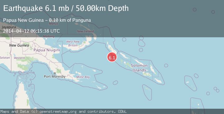
A 6.1 magnitude earthquake struck on SOLOMON ISLANDS, at Sat, 12 Apr 2014 06:15:38 GMT. Depth: 50km. Reviewed by EMSC seismologists, this strong quake occurred at a magnitude type of mb.
Magnitude
6.1
mb
Source
EMSC
Intensity
-
Agency Reports
2 Sources| Source | Magnitude | Depth | Time |
|---|---|---|---|
| EMSCPrimary | 6.1 | 60 km | 11 years ago |
| NEIC | 5.1 | 35 km | 11 years ago |
Earthquake Details
AutomaticEvent IDemsc_EMSC_20140412_0000029
Tsunami PotentialNo
Magnitude Typemb
Nearest Places
- 31.4 km
- 31.9 km
- 32.7 km
- 33.3 km
- 34.3 km
Comments
Join the discussion about this event.
Latest Earthquakes
0.6Mag
2 km NW of The Geysers, CA
Time6 minutes ago
Depth3.79 km
SourceUSGS (Automatic)
3.2Mag
Peru-Bolivia border region
Time8 minutes ago
Depth139.65 km
SourceVYT (Automatic)
3.4Mag
Panama-Colombia border region
Time8 minutes ago
Depth10.00 km
SourceVYT (Automatic)
3.7Mag
Minahasa, Sulawesi, Indonesia
Time9 minutes ago
Depth0.00 km
SourceVYT (Automatic)
3.0Mag
DODECANESE ISLANDS, GREECE
Time11 minutes ago
Depth18.70 km
SourceNOA (Automatic)
Nearby Earthquakes
5.3Mag
SOLOMON ISLANDS
Time18 years ago
Depth33.00 km
SourceEMSC (Automatic)
5.7Mag
SOLOMON ISLANDS
Time11 years ago
Depth10.00 km
SourceEMSC (Automatic)
5.6Mag
SOLOMON ISLANDS
Time18 years ago
Depth10.00 km
SourceEMSC (Automatic)
6.4Mag
SOLOMON ISLANDS
Time15 years ago
Depth424.00 km
SourceEMSC (Automatic)
6.1Mag
SOLOMON ISLANDS
Time11 years ago
Depth20.00 km
SourceEMSC (Automatic)