Earthquake KEPULAUAN BARAT DAYA, INDONESIA
Wed, 06 Aug 2014 11:45:24 GMT
Time11 years ago
Location
-7.3100, 128.1000
Depth
10.0 KM
Event Summary
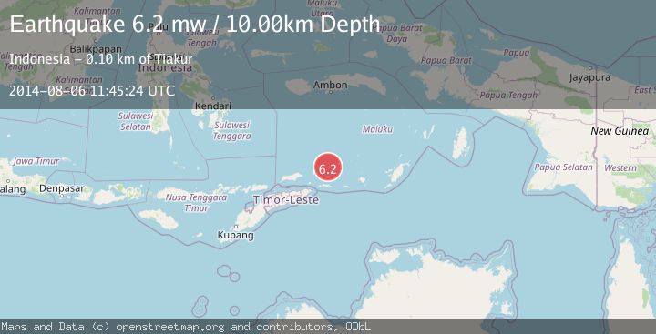
A 6.2 magnitude earthquake struck on KEPULAUAN BARAT DAYA, INDONESIA, at Wed, 06 Aug 2014 11:45:24 GMT. Depth: 10km. Reviewed by EMSC seismologists, this strong quake occurred at a magnitude type of mw.
Magnitude
6.2
mw
Source
EMSC
Intensity
-
Agency Reports
1 Sources| Source | Magnitude | Depth | Time |
|---|---|---|---|
| EMSCPrimary | 6.2 | 10 km | 11 years ago |
Earthquake Details
AutomaticEvent IDemsc_EMSC_20140806_0000027
Tsunami PotentialNo
Magnitude Typemw
Nearest Places
- Kepulauan Barat Daya16.2 km
- Pulau Musleur34.5 km
- Tanjung Tutitlakani50.9 km
- Pulau Terbang Utara51.0 km
- Pulau Terbang Selatan51.0 km
Comments
Join the discussion about this event.
Latest Earthquakes
1.8Mag
Central Alaska
Time6 hours ago
Depth103.03 km
SourceVYT (Automatic)
2.6Mag
Northern Sumatra, Indonesia
Time6 hours ago
Depth20.84 km
SourceBMKG
1.3Mag
Washington
Time6 hours ago
Depth0.00 km
SourceVYT (Automatic)
1.6Mag
Kenai Peninsula, Alaska
Time6 hours ago
Depth21.36 km
SourceVYT (Automatic)
2.4Mag
Java, Indonesia
Time6 hours ago
Depth23.99 km
SourceBMKG
Nearby Earthquakes
5.0Mag
KEPULAUAN BARAT DAYA, INDONESIA
Time11 years ago
Depth30.00 km
SourceEMSC (Automatic)
5.1Mag
KEPULAUAN BARAT DAYA, INDONESIA
Time12 years ago
Depth4.00 km
SourceEMSC (Automatic)
4.0Mag
KEPULAUAN BARAT DAYA, INDONESIA
Time3 years ago
Depth140.00 km
SourceNEIC (Automatic)
3.0Mag
Banda Sea
Time1 week ago
Depth211.06 km
SourceVYT (Automatic)
5.2Mag
KEPULAUAN BARAT DAYA, INDONESIA
Time21 years ago
Depth20.00 km
SourceEMSC (Automatic)