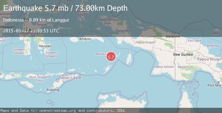
Earthquake BANDA SEA
Sat, 17 Jan 2015 23:39:53 GMT
Time11 years ago
Location
-5.8400, 131.9000
Depth
73.0 KM
Event Summary
A 5.7 magnitude earthquake struck on BANDA SEA, at Sat, 17 Jan 2015 23:39:53 GMT. Depth: 73km. Reviewed by EMSC seismologists, this moderate quake occurred at a magnitude type of mb.
Magnitude
5.7
mb
Source
EMSC
Intensity
-
Agency Reports
1 Sources| Source | Magnitude | Depth | Time |
|---|---|---|---|
| EMSCPrimary | 5.7 | 73 km | 11 years ago |
Earthquake Details
AutomaticEvent IDemsc_EMSC_20150117_0000076
Tsunami PotentialNo
Magnitude Typemb
Nearest Places
- Pulau Fadol19.5 km
- Desa Tiflen19.6 km
- Pulau-pulau Tigasaudara25.3 km
- Tanjung Melik29.3 km
- Pulau Wonim29.4 km
Comments
Join the discussion about this event.
Latest Earthquakes
2.8Mag
Valparaiso, Chile
Time2 minutes ago
Depth136.11 km
SourceVYT (Automatic)
1.3Mag
7 km ENE of Aromas, CA
Time3 minutes ago
Depth5.11 km
SourceUSGS (Automatic)
1.3Mag
Kenai Peninsula, Alaska
Time4 minutes ago
Depth0.00 km
SourceVYT (Automatic)
2.9Mag
Ceram Sea
Time8 minutes ago
Depth12.24 km
SourceBMKG
2.2Mag
CENTRAL CALIFORNIA
Time9 minutes ago
Depth4.00 km
SourceNC (Automatic)
Nearby Earthquakes
3.1Mag
BANDA SEA
Time1 month ago
Depth619.00 km
SourceBMKG (Automatic)
4.0Mag
BANDA SEA
Time3 years ago
Depth111.00 km
SourceDJA (Automatic)
5.2Mag
BANDA SEA
Time2 years ago
Depth75.00 km
SourceEMSC (Automatic)
5.6Mag
Kepulauan Tanimbar, Indonesia
Time12 hours ago
Depth146.36 km
SourceVYT (Automatic)
3.7Mag
KEP. TANIMBAR REGION, INDONESIA
Time0 months ago
Depth78.00 km
SourceBMKG (Automatic)