Earthquake SOUTHERN SUMATRA, INDONESIA
Mon, 12 Sep 2016 15:10:12 GMT
Time9 years ago
Location
-4.9500, 101.7800
Depth
40.0 KM
Event Summary
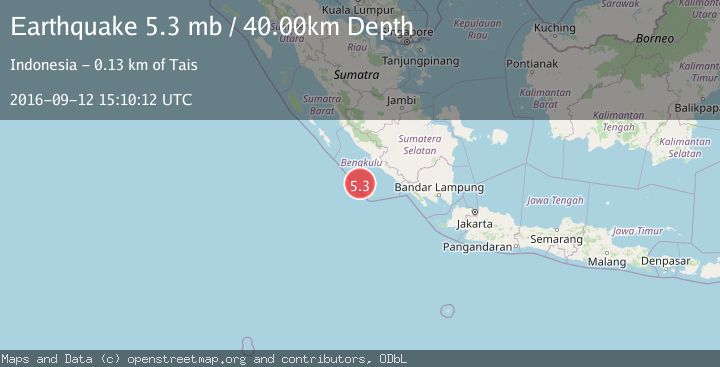
A 5.3 magnitude earthquake struck on SOUTHERN SUMATRA, INDONESIA, at Mon, 12 Sep 2016 15:10:12 GMT. Depth: 40km. Reviewed by EMSC seismologists, this moderate quake occurred at a magnitude type of mb.
Magnitude
5.3
mb
Source
EMSC
Intensity
-
Agency Reports
1 Sources| Source | Magnitude | Depth | Time |
|---|---|---|---|
| EMSCPrimary | 5.3 | 40 km | 9 years ago |
Earthquake Details
AutomaticEvent IDemsc_EMSC_20160912_0000111
Tsunami PotentialNo
Magnitude Typemb
Nearest Places
- Sungai Hubaje56.0 km
- Lakoaha56.5 km
- Tanjung Lakoaha56.7 km
- Batang Mea57.1 km
- Tanjung Kooma57.2 km
Comments
Join the discussion about this event.
Latest Earthquakes
2.3Mag
Sumba Region, Indonesia
Time5 minutes ago
Depth7.66 km
SourceBMKG
3.6Mag
Southern Alaska
Time10 minutes ago
Depth10.74 km
SourceVYT (Automatic)
2.5Mag
NEAR THE COAST OF WESTERN TURKEY
Time10 minutes ago
Depth6.80 km
SourceKOERI (Automatic)
4.0Mag
OFF COAST OF NORTHERN PERU
Time14 minutes ago
Depth48.00 km
SourceLIM (Automatic)
3.2Mag
NEAR EAST COAST OF HONSHU, JAPAN
Time14 minutes ago
Depth30.00 km
SourceJMA (Automatic)
Nearby Earthquakes
5.5Mag
SOUTHERN SUMATRA, INDONESIA
Time14 years ago
Depth53.00 km
SourceEMSC (Automatic)
5.4Mag
SOUTHWEST OF SUMATRA, INDONESIA
Time14 years ago
Depth20.00 km
SourceEMSC (Automatic)
4.0Mag
SOUTHERN SUMATRA, INDONESIA
Time4 months ago
Depth10.00 km
SourceBMKG (Automatic)
4.3Mag
SOUTHWEST OF SUMATRA, INDONESIA
Time1 month ago
Depth26.10 km
SourceNEIC (Automatic)
4.0Mag
SOUTHERN SUMATRA, INDONESIA
Time6 years ago
Depth21.00 km
SourceDJA (Automatic)