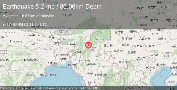
Earthquake MYANMAR-INDIA BORDER REGION
Sat, 04 Mar 2017 02:11:53 GMT
Time8 years ago
Location
25.1500, 94.8300
Depth
80.0 KM
Event Summary
A 5.2 magnitude earthquake struck on MYANMAR-INDIA BORDER REGION, at Sat, 04 Mar 2017 02:11:53 GMT. Depth: 80km. Reviewed by EMSC seismologists, this moderate quake occurred at a magnitude type of mb.
Magnitude
5.2
mb
Source
EMSC
Intensity
-
Agency Reports
1 Sources| Source | Magnitude | Depth | Time |
|---|---|---|---|
| EMSCPrimary | 5.2 | 80 km | 8 years ago |
Earthquake Details
AutomaticEvent IDemsc_EMSC_20170304_0000015
Tsunami PotentialNo
Magnitude Typemb
Nearest Places
- 4.9 km
- 5.2 km
- 5.4 km
- 6.2 km
- 8.3 km
Comments
Join the discussion about this event.
Latest Earthquakes
2.0Mag
Poland
Time1 minute ago
Depth5.62 km
SourceVYT (Automatic)
2.6Mag
Southern Alaska
Time9 minutes ago
Depth42.60 km
SourceVYT (Automatic)
2.8Mag
south of Java, Indonesia
Time10 minutes ago
Depth0.00 km
SourceVYT (Automatic)
2.9Mag
southern Sumatra, Indonesia
Time14 minutes ago
Depth32.71 km
SourceVYT (Automatic)
3.1Mag
Halmahera, Indonesia
Time15 minutes ago
Depth9.55 km
SourceBMKG
Nearby Earthquakes
4.2Mag
MYANMAR-INDIA BORDER REGION
Time3 weeks ago
Depth105.50 km
SourceNDI (Automatic)
4.0Mag
MYANMAR-INDIA BORDER REGION
Time5 years ago
Depth82.00 km
SourceNDI (Automatic)
5.1Mag
MYANMAR-INDIA BORDER REGION
Time4 years ago
Depth100.00 km
SourceEMSC (Automatic)
4.0Mag
MYANMAR-INDIA BORDER REGION
Time2 years ago
Depth116.00 km
SourceEMSC (Automatic)
4.0Mag
MYANMAR-INDIA BORDER REGION
Time3 years ago
Depth10.00 km
SourceNDI (Automatic)